
Islay, Carragh Bhan


Standing Stone(S) (Prehistoric)
Site Name Islay, Carragh Bhan
Classification Standing Stone(S) (Prehistoric)
Canmore ID 37610
Site Number NR34NW 7
NGR NR 32832 47816
Datum OSGB36 - NGR
Permalink http://canmore.org.uk/site/37610


- Council Argyll And Bute
- Parish Kildalton And Oa
- Former Region Strathclyde
- Former District Argyll And Bute
- Former County Argyll
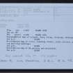
NR34NW 7 3283 4781.
(NR 3282 4782) Carragh Bhan (NR)
OS 6" map, Buteshire, 2nd ed., (1900)
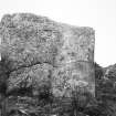
Carragh Bhan: This very large and broad standing stone traditionally marks the grave of King Godred Crovan. Several smaller and possibly related stones have been noted nearby (Celoria 1959).
Name Book 1878; F Celoria 1959.
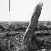
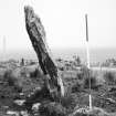
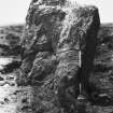
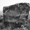
NR 3283 4781 Carragh Bhan: name unconfirmed. A prominent standing slab above an east facing slope, with extensive views in that direction. It stands 2.3m high and broad and 0.5m thick at base, and is orientated north east-south west with a slight lean to west north west.
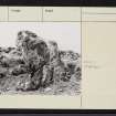
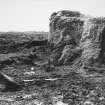
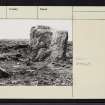
Recent ground disturbance here has exposed two nearby stones stumps, both measuring 0.8m by 0.2m and now protruding 0.3m above ground level. Together with a partially buried slab, showing as 0.5m by 0.4m, they are amongst a scatter of earth fast stones around the main stone and their association, if any, is uncertain.
Standing stone surveyed at 1:10000.
Visited by OS (JRL) 8 June 1978.
Field Visit (June 1976)
NR 328 478. This impressive slab stands on level ground 400m W of Grianan and 20m wsw of the public road from Port Ellen to Kintra*. Now leaning slightly to the WNW it is aligned with its axis NNE and SSW; appearing almost square in elevation, it measures 2.2m by 0.5m at the base and 2.2m in height.
Less than 1m to the S is what appears to be the stump of a smaller standing stone: measuring 0.8m by 0.2m, it is aligned NNW and SSE and projects through the turf to a maximum height of 0.3m. About 3m to the ESE there is a second stump, of similar dimensions, aligned N and S.
RCAHMS 1984, visited June 1976
*This stone is identified in local tradition as the grave of Godred Crovan, King of Man and the Isles, who died in 1095 (Lamont 1966, 16)
Measured Survey (1976)
The standing stones at Carragh Bhan were surveyed at 1:100 by RCAHMS. The plan was redrawn in ink and published at a reduced scale (RCAHMS 1984, fig.65B).

