|
Manuscripts |
MS 460 |
Records of the Royal Commission on the Ancient and Historical Monuments of Scotland (RCAHMS), Edinbu |
Supplementary list (to Argyll Inventory vol. 5) of rural settlements and shielings in Islay, Jura and Colonsay. |
1985 |
Item Level |
|
 |
On-line Digital Images |
DP 021093 |
RCAHMS Aerial Photography Digital |
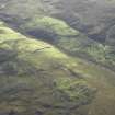
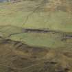
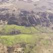
General oblique aerial view centred on the remains of the farmstead, chapel, enclosure, townships, rig and lazy beds, taken from the N. |
2/11/2006 |
Item Level |
|
 |
On-line Digital Images |
DP 021094 |
RCAHMS Aerial Photography Digital |
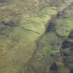
General oblique aerial view centred on the remains of the farmstead, chapel, enclosure, townships, rig and lazy beds, taken from the NNW. |
2/11/2006 |
Item Level |
|
 |
On-line Digital Images |
DP 021095 |
RCAHMS Aerial Photography Digital |
General oblique aerial view centred on the remains of the farmstead, chapel, enclosure, townships, rig and lazy beds, taken from the NNW. |
2/11/2006 |
Item Level |
|
 |
On-line Digital Images |
DP 021096 |
RCAHMS Aerial Photography Digital |
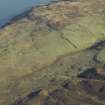
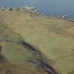
General oblique aerial view centred on the remains of the farmstead, chapel, enclosure, townships, rig and lazy beds, taken from the WSW. |
2/11/2006 |
Item Level |
|
 |
On-line Digital Images |
DP 021097 |
RCAHMS Aerial Photography Digital |
General oblique aerial view centred on the remains of the farmstead, chapel, enclosure, townships, rig and lazy beds, taken from the SSW. |
2/11/2006 |
Item Level |
|
 |
On-line Digital Images |
DP 021098 |
RCAHMS Aerial Photography Digital |
General oblique aerial view centred on the remains of the farmstead, chapel, enclosure, townships, rig and lazy beds, taken from the SE. |
2/11/2006 |
Item Level |
|
 |
On-line Digital Images |
DP 021099 |
RCAHMS Aerial Photography Digital |
General oblique aerial view centred on the remains of the farmstead, chapel, enclosure, townships, rig and lazy beds, taken from the ESE. |
2/11/2006 |
Item Level |
|
 |
On-line Digital Images |
DP 112381 |
RCAHMS Aerial Photography Digital |
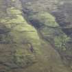
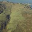
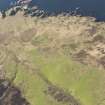
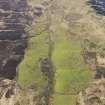
General oblique aerial view of the remains of the field systems and farmsteads at Sruthan Poll Nan Gamhna, Islay, taken from the SSE. |
3/5/2011 |
Item Level |
|
 |
On-line Digital Images |
DP 112382 |
RCAHMS Aerial Photography Digital |
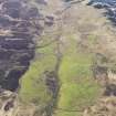
General oblique aerial view of the remains of the field systems and farmsteads at Sruthan Poll Nan Gamhna, Islay, taken from the ESE. |
3/5/2011 |
Item Level |
|
 |
On-line Digital Images |
DP 112383 |
RCAHMS Aerial Photography Digital |
General oblique aerial view of the remains of the field systems and farmsteads at Sruthan Poll Nan Gamhna, Islay, taken from the ESE. |
3/5/2011 |
Item Level |
|
 |
On-line Digital Images |
DP 112384 |
RCAHMS Aerial Photography Digital |
General oblique aerial view of the remains of the field systems and famsteads at Sruthan Poll Nan Gamhna, Islay, taken from the ESE. |
3/5/2011 |
Item Level |
|
 |
On-line Digital Images |
DP 112385 |
RCAHMS Aerial Photography Digital |
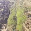
General oblique aerial view of the remains of the field systems and farmsteads at Sruthan Poll Nan Gamhna, Islay, taken from the ENE |
3/5/2011 |
Item Level |
|
 |
On-line Digital Images |
DP 112386 |
RCAHMS Aerial Photography Digital |
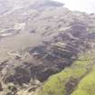
General oblique aerial view of the remains of the field systems and farmsteads at Sruthan Poll Nan Gamhna, Islay, taken from the NE. |
3/5/2011 |
Item Level |
|
 |
On-line Digital Images |
SC 2414112 |
Records of the Ordnance Survey, Southampton, Hampshire, England |
Islay, Sruthan Poll Nan Gamhna, NR34NW 29, Ordnance Survey index card, Recto |
c. 1958 |
Item Level |
|


