
Pricing Change
New pricing for orders of material from this site will come into place shortly. Charges for supply of digital images, digitisation on demand, prints and licensing will be altered.
Upcoming Maintenance
Please be advised that this website will undergo scheduled maintenance on the following dates:
Thursday, 9 January: 11:00 AM - 3:00 PM
Thursday, 23 January: 11:00 AM - 3:00 PM
Thursday, 30 January: 11:00 AM - 3:00 PM
During these times, some functionality such as image purchasing may be temporarily unavailable. We apologise for any inconvenience this may cause.
Islay, Tockmal


Horizontal Mill (Period Unassigned)(Possible), Lime Kiln (Period Unassigned), Township (Period Unassigned)
Site Name Islay, Tockmal
Classification Horizontal Mill (Period Unassigned)(Possible), Lime Kiln (Period Unassigned), Township (Period Unassigned)
Alternative Name(s) Kintra
Canmore ID 37602
Site Number NR34NW 26
NGR NR 30056 47260
NGR Description Centred NR 3006 4723
Datum OSGB36 - NGR
Permalink http://canmore.org.uk/site/37602


- Council Argyll And Bute
- Parish Kildalton And Oa
- Former Region Strathclyde
- Former District Argyll And Bute
- Former County Argyll
NR34NW 26 centred 3006 4723
See also NR34NW 15.
Manuscript annotation on RCAHMS working map indicates possible horizontal mills or vertical wheel on the SW side of the township.
(Undated) information in NMRS.
(All letters/numbers refer to RCAHMS 1984 published plan from the Inventory)
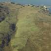
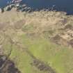
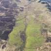
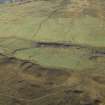
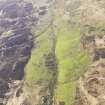
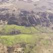
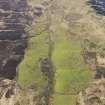
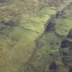
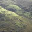
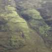
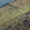
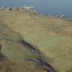
The ruins of this deserted township are situated on the N slopes of Maol Chnoc, close to the confluence of two
unnamed tributaries of the Sruthan Poll nan Gamhna and about 100m SE of the chapel NR24NE 1. The site comprises, to the N and E, an extensive area of rig-cultivation, (A cup-marked boulder (NR34NW 3) is situated within the tracts of rigs to the E of the township) and the main groups of buildings are laid out in a linear arrangement, aligned in accordance with a gradual fall in ground level from E to NW, The township was served by at least four paths or tracks, but the hollow-way that approached the site from the SE appears to have been subsequently converted into a small dam and channelled watercourse for what was probably a water-mill within the complex (Buildings Hand J).
The buildings, which were formerly thatched, are roofless, but the side-walls in parts stand to their original heights of up
to 2.5m and some of the buildings also preserve much of their square-angled gables. There is, however, no surviving
evidence ofcruck framing. The masonry is random rubble of local origin comprising field-boulders and slab pinnings laid
in a mud mortar which has a sandy admixture and occasional traces of lime pointing. ((There are remains of a well-preserved lime-kiln at a neighbouring township [NR34NW 29], 0.6km to the NE of Tockmal) The enclosure-dykes are of drystone-and-turf construction. The units that make up the main ranges (A and B) exhibit much evidence of reconstruction and modification.
Building B1, which stands detached and on a slightly different alignment from the longer range A, represents the
remains of the dwelling-house in the latest phases of occupation. It is a substantial structure measuring 15m by
6.1m over walls 1m in average thickness. Alterations, which are indicated mainly by straight joints in the masonry,
include the insertion of a cross-wall dividing off the lower third of the building. Much of the NE side-wall (which
possesses a small aumbry) and the NW gable-wall, which incorporates a mural fireplace and chimney-flue, may also
have been part of a later reconstruction. There is a surviving original window in the SW side-wall which has through splays from sharp external arrises. Narrower ancillary units (Bl and B2) abut the NW gable-wall and themselves show signs of rebuilding.
Between the central units A2 and A3 in the longer range there is a cross-wall which has a blocked-up
intercommunicating doorway and an aurnbry on its w face, conceivably a vestige of an earlier dwelling with an open
hearth placed somewhere towards the upper end of A3. The foundations of older side- and end-walls in areas A1 and A4 may also be associated with this earliest phase, but the entire range was subsequently remodelled for agricultural
purposes. Four of the surviving units retain evidence of opposed entrances in the side-walls, most of which were later
wholly or partially blocked. The only visible internal feature of note is part of a kerbed transverse drainage-channel in A]. At the NW external angle of unit A5 there is a large projecting boulder bearing a cup-shaped depression, (DES 1962) possibly a small mortar. A partly revetted platform runs along the SW side of this range of buildings, where the adjacent track appears to have been converted into a lade. The slight remains of buildings H and J do not permit a precise functional identification but, judging from their positions close to where the later water-course empties into the burn, it is likely that the larger building (H) at least was used for water-powered threshing or milling.
Other ancillary buildings (C-G) are situated to the NE of the main ranges and are contiguous with some of the dyked
enclosures. The foundations of building E show that it was of two compartments, later extended more narrowly to a range of four. Beyond the short stretch of drystone walling at the NW end are the remains of a detached corn-drying kiln (F). The kiln contains a circular bowl 1.8m in diameter, and the flue is in the E sector. The foundations situated on the ridge about 30m SE of unit A1 may represent the slight remains of another kiln, in this case possibly of oblong plan.
None of the surviving remains is demonstrably older than the early decades of the 19th century, but the existence of the adjacent medieval chapel, coupled with the survival of early historical records relating to the lands and tenancy of Tockmal, implies the presence of settlement in this area since at least the early 15th century.(Islay Book; Proc R I A 1960) The farm of Tockmal had for long been ajoint tenancy of three tenants who, together with their families and one cottar, in 1839, made up a total population of twenty-four persons and possessed six horses.('Description of the population of Oa 1839' in the Kildalton Papers [microfilm SRO, RH4/92/2.])
The number of tenants was reduced to two at some date before 1843, and by 1848 the lease was being renewed
annually by the Islay estate. (ibid, Kildalton Papers) Like Lurabus the township was probably abandoned during the third quarter of the 19th century.
RCAHMS 1984, visited June 1980.
A township comprising five unroofed buildings, one of which is a long building of three compartments, one unroofed structure, five enclosures and an Old Limekiln are depicted on the OS 1st edition 6-inch map (Argyllshire 1882, sheet ccxxxi). Seven unroofed buildings and one enclosure are shown on the current edition of the OS 1:10000 map (1981).
Information from RCAHMS (SAH), 4 December 1998.

