
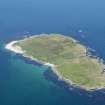
Nave Island


Settlement (Viking)(Possible)
Site Name Nave Island
Classification Settlement (Viking)(Possible)
Canmore ID 37473
Site Number NR27NE 2
NGR NR 29158 75925
Datum OSGB36 - NGR
Permalink http://canmore.org.uk/site/37473


- Council Argyll And Bute
- Parish Kilchoman
- Former Region Strathclyde
- Former District Argyll And Bute
- Former County Argyll
NR27NE 2 2913 7593.
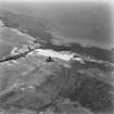
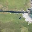
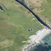
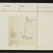
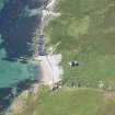
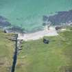
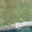
NR 290 758. An oval mound 20yds long by 9yds wide lying NW-SE and having a ramp at the SE end lies 71 yds NNW of NR27NE 1. A cluster of 25 stones is exposed in the centre of the mound, a cluster of 7 stones lies at the northern end and numerous isolated stones protrude through the grass surface. Investigation established the presence of stones, possibly constituting the remains of walls round the upper perimeter but the nature of the structure was not established. A partial resistivety survey of the oval 'hut' of boat-shaped outline showed anomalies at the ramp end and at the centre.
M Rivlin 1961.
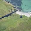
At NR 2913 7593, towards the summit of a low saddle on a gentle SE facing slope some 90m from high water mark, are the turf covered footings of a boat-shaped building. It is levelled up on the slope, and measures about 17.4m NW-SE by 6.8m transversely within a wall 0.3m maximum internal height, but 1.0m external height at the SE downslope end. Several outer facing stones and one inner are exposed indicating a wall thickness of 1.0m in the SW side, but it widens to a 2.8m spread in the SE. An entrance gap occurs in the NW end. In the centre is a pile of loose, partially turf covered stones, 3.5m in diameter and 0.3m high, which is probably a later dump. This building may be the remains of Viking longhouse, but it could be associated with the nearby 18th century kelp burning industry.
Surveyed at 1:10 000.
Visited by OS (N KL B) 15 June 1978.
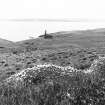
NR 2903 7594 Just outside the outer of the two enclosures associated with the chapel, on the summit of a low hill, is a small hollow identified on OS maps as a well. Standing in it, and now broken in two, is a thin slab of greywacke, less than 1m high, which might be the shaft of a small cross, perhaps marking the boundary of an early monastic settlement supposed to have been here. In a sheltered position within the outer enclosure and surrounded by rigs is a barrel-shaped house with turf walls and a prominent lump in the centre of its interior. It measures 22.5m in overall length, 10m wide at maximum, narrowing at the ends to 8.5m. It shows clearly on the aerial photograph of the Islay Inventory (RCAHMS 1984, 225) but is not commented on.
D H Caldwell, R McWee and N A Ruckley 1999
Field Visit (31 March 2022)
NR 290 758 Previous archaeological survey on Nave Island (Canmore ID: 37473) had identified a barrel shaped earthwork. This has not been systematically surveyed and has received various interpretations, including a Viking house, Viking boat burial, or a structure relating to the 19th-century kelp industry on the island. To formally record and begin an investigation of this structure an earthwork and geophysical survey was undertaken on 31 March 2022.
The geophysics survey was undertaken by Magnitude Surveys using Earth Resistance and Ground Penetrating Radar methods. The results of the earthwork and geophysics survey correspond well, showing the structure has curved or bow shaped long walls and rounded ends, with an internal length of 16.5m and width of
6.5m. It was shown to predate the rig and plough that surrounded it. The geophysics detected internal structure, possible a ditch or the remains of an earlier wall. The most likely interpretation remains that of a Viking house.
Archive: Islay Museum of Island Life
Funder: Viking Society for Northern Britain and University of Reading
Steven Mithen and Elaine Jamieson – University of Reading
(Source: DES Volume 23)

