
Pricing Change
New pricing for orders of material from this site will come into place shortly. Charges for supply of digital images, digitisation on demand, prints and licensing will be altered.
Gretna, Hm Factory, Eastriggs Explosives Factory, Explosives Magazines


Blast Mound(S) (Second World War), Magazine(S) (Second World War)
Site Name Gretna, Hm Factory, Eastriggs Explosives Factory, Explosives Magazines
Classification Blast Mound(S) (Second World War), Magazine(S) (Second World War)
Canmore ID 374050
Site Number NY26NW 46.12
NGR NY 248 662
NGR Description centred
Datum OSGB36 - NGR
Permalink http://canmore.org.uk/site/374050


- Council Dumfries And Galloway
- Parish Dornock
- Former Region Dumfries And Galloway
- Former District Annandale And Eskdale
- Former County Dumfries-shire
Field Visit (7 September 2022 - 9 September 2022)
Canmore ID 374050
NY26NW 46.12
NY 266 564
The 'R' numbering for the structures used in this text was in use by 2012 (Ministry of Defence DM Eastriggs Dumfries & Galloway, MOD Boundary and Buildings Plan, 2012), although it is uncertain when it was introduced.
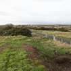
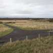
There are 74 steel-framed, brick-panelled buildings that served as magazines, and are spread throughout the area delimited by the Second World War security fence (NY26NW 46.20). Two further buildings (NY 25495 64850 and NY 25329 64710) were destroyed when the Transit Area (NY26NW 46.21) was constructed in the 1980s. The orientations of the buildings are governed by the narrow-gauge railway network (NY26NW 46.27) on which the ammunition was moved around the depot, but this was also conditioned by the shape of the available space. In addition, there was clearly a requirement to maintain a distance of some 180m to 210m between the buildings. Each is rectangular on plan and measures 30m in length by 12m transversely within brickwork 0.11m–0.23m in thickness and 5m in height. They have all been erected on a concrete platform extending a short distance beyond the footings. All are single storeyed with flat reinforced cast concrete roofs resting on ‘I’ beams and covered with a layer of bitumen. There was guttering around the buildings, with downpipes at each corner and also at intervals along the longer elevations. The downpipes at the corners conveyed the water to circular concrete tubs situated slightly behind the frontage of the buildings. Some of the buildings have two double doors in their gable ends (e.g. R1, R11, R25, R33, R46), while others have at least four double doors in one of their longer elevations (e.g. R36, R40, R58, R67, R72). In either case, these doorways face directly onto the narrow-gauge railway lines. All these double doors were originally protected by porches. However, only one example survives (R1) and this is in a gable end. It has a flat cast-concrete roof and a brick outer wall with shallow pilasters. Nevertheless, fragments of cement above some of the doorways elsewhere indicate that porches were also constructed using corrugated iron sheeting over a metal framework (e.g. R63). Single doorways also sometimes occur but these rarely face onto the narrow-gauge railway lines. The longer sides of the buildings originally had six rectangular metal framed windows in the upper brick panels each with six panes initially. A few buildings retain traces of their original camouflage which appears to have comprised dark vertical stripes that perhaps contrasted with a lighter colour (e.g. R34). Their interiors are divided into two equal halves by eleven steel uprights which run the length of the building. These are spaced at intervals of about 3m and match those in the outer frame. In at least one example a corner has been separated from the rest of the interior by a brick-built compartment entered by a double door (R59).
In the event of explosion, the walls of these explosives magazines were designed to collapse allowing the roof to fall and suffocate a fire. Any such explosion needed to be repelled by the blast mounds to prevent a chain reaction across the Depot. Most of these buildings are surrounded by earth and stone blast mounds which are also rectangular on plan and measure 35m-37m in length by 15m-17m transversely within grass-grown, earth and stone banks 12m-15m in breadth and 4m-5m in height. Some have neat, rounded corners (e.g. R30, R31, R32), but in others these are much sharper (e.g. R16, R27, R28). A narrow-gauge railway line entered and left through cuttings, the butt ends of which were revetted by brick or concrete depending on the pressure they were expected to sustain. Points would allow one train to loop around another waiting in front of a building. There is some variability in the provision of enclosing blast mounds, including those with three (R22, R23, R29, R46), those with two (R21, R52), those with one (R8, R12-14) and those with none (R17, R24, R26, R32, R34-36, R38-45, R67-70, R74). A pre-existing road could influence their character (R21, R46) or even the presence of boggy ground (R52). In certain instances, the bank of the blast mound lying parallel with the axis of the railway line stretches further than the external edges of the remainder of the earthwork (R9, R10, R15, R16, R20, R27, R28, R64, R73) and indeed a few are a great deal longer (R30, R31, R33, R37, R72). Moreover, two are even more unusual in curling at one end (R21, R46) and one (R45) was clearly intended to enclose not only the building and the hard standing to its S, but also ground to its N.
There is evidence of a significant restoration comprising the renovation of some of the brickwork in the buildings (e.g. R38), and the butt ends of the bunds (e.g. R65). In addition, a number of the doorways have been modified (e.g. R45, R46) and there is evidence that the camouflage was overpainted white. Moreover, a numeral was painted on the gable of each building as an identifier (e.g. R24, 65). A later restoration resulted in the cladding of thirty-five of the buildings (e.g. R4, R12, R25, R39, R48, R52, R69). This comprised a light green, steel shell with a low ridged roofline, which was placed over the entire structure and included new porticoes above the doors. Each window pairing was covered with a perspex sheet and where there were vents close to the floor these were provided with new covers.
The R buildings are not visible on aerial photographs (M124/13) flown on 19 August 1940 but are approaching completion on a later series of aerial photographs (CAM/031/06209 – 06212) flown on 13 October 1942. These show that most of the blast mounds had been completed, with some yet to be built (e.g. R8, R12-14). There is evidence for a change of plan during the works. One side of a part-finished blast mound situated immediately ENE of the Brine Tower (NY26SE 16.1) that survives from the First World War Factory, was constructed. A brick-built revetment at its S end shows that the original intention was to reuse the embankment of the First World War narrow gauge railway line (NY26NW 46.23), which runs at right angles to it. The idea may have been abandoned when the value of the Brine Tower was recognised if converted to an observation post. The aerial photographs also show that there were individual porches over each of the double doorways situated in the gables (e.g. R20, R22, R28, R29, R50), but a single lengthy porch was provided where there were four doorways in the longer elevation (e.g. R37, R38, R51, R54, R55). In some places, narrow-gauge trains are drawn up at these doorways and are visible on lines elsewhere in the network. Oblique aerial photographs taken on 6 May 1975 (39/RAF/4701 P0024-0027) show that the individual porches above the gable ended buildings shown on the 1942 photographs had been replaced by a single porch. In addition, lightning rods had been provided for each of the buildings and their walls had been newly painted white. Aerial photographs flown on 13 June 1988 (ASS/62588 0110-11) indicate that the steel cladding had yet to be introduced and in practice it seems likely that this occurred during major restoration that also led to the introduction of the lengthiest blast mound bunds (R21, R45-46).
Two of the buildings forming part of this numbered series (R18, R19) were originally drying houses (see NY26NE 146.1).
LIST OF 'R' building National Grid Reference co-ordinates:
R1: NY 24370 65364, R2: NY 24594 65313, R3: NY 24775 65242,
R4: NY 24225 65198, R5: NY 24449 65147, R6: NY 24664 65054,
R7: NY 24300 64992, R8: NY 24487 64934, R9: NY 25033 65202,
R10: NY 24876 65055, R11: NY 25066 64988, R12: NY 24766 64868,
R13: NY 24958 64801, R14: NY 25146 64750, R15: NY 25224 65303,
R16: NY 25253 65111, R17: NY 25283 64919, R18: NY 25847 65075,
R19: NY 25915 65056, R20: NY 25531 64612, R21: NY 25799 64380,
R22: NY 25722 64572, R23: NY 25953 64527, R24: NY 25437 65223,
R25: NY 25673 65000, R26: NY 25861 64946, R27: NY 25467 65031,
R28: NY 25715 64789; R29: NY 25911 64738, R30: NY 25390 65423,
R31: NY 25617 66385, R32: NY 25707 65213, R33: NY 25824 65413,
R34: NY 25954 65252, R35: NY 26035 65075, R36: NY 26032 65462,
R37: NY 26166 65250, R38: NY 26233 65439, R39: NY 26369 65250,
R40: NY 26251 65052, R41: NY 26466 65054, R42: NY 26684 65078,
R43: NY 26073 64877, R44: NY 26101 64684, R45: NY 26140 64426,
R46: NY 25948 64238, R47: NY 26336 64252, R48: NY 26546 65297,
R49: NY 26838 64346, R50: NY 26137 64160, R51: NY 26285 64007,
R52: NY 26479 64094, R53: NY 26675 64013, R54: NY 26848 64142,
R55: NY 27039 64262, R56: NY 27229 64362, R57: NY 27403 64487,
R58: NY 26354 64456, R59: NY 26564 64500, R60: NY 26775 64538,
R61: NY 26990 64552, R62: NY 27205 64565, R63: NY 27223 64773,
R64: NY 27177 64992, R65: NY 27422 64704, R66: NY 27374 64916,
R67: NY 27573 64846, R68: NY 27487 65098, R69: NY 27337 65254,
R70: NY 27599 64567, R71: NY 27761 64710, R72: NY 27752 64929,
R73: NY 27683 65131, R74: NY 27545 65299, R unnumbered: NY 25495 64850 USN/219/206 0013 (26 July 1963, destroyed), R unnumbered: NY 25329 64710 (CAM/032/06209, 13 October 1942, destroyed).
Visited by HES Heritage Recording (MMD and ATW), 7-9 September 2022

