Accessibility

Font Size

100% 150% 200%

Background Colour

Default Contrast
Close Reset

Islay, Port Charlotte

Village (19th Century)

Site Name Islay, Port Charlotte

Classification Village (19th Century)

Canmore ID 37302

Site Number NR25NE 14

NGR NR 2526 5817

NGR Description Centred NR 2526 5817

Datum OSGB36 - NGR

Permalink http://canmore.org.uk/site/37302

Ordnance Survey licence number AC0000807262. All rights reserved.
Canmore Disclaimer. © Bluesky International Limited 2025. Public Sector Viewing Terms

Toggle Aerial | View on large map

Digital Images

Islay, Port Charlotte
View looking NNW showing back green and ESE fronts of cottages on N tip of Shore Street
Islay, Port Charlotte
View looking NNW showing back green and ESE fronts of cottages on N tip of Shore StreetGeneral oblique aerial view centred on the village, taken from the W.General oblique aerial view centred on the village, taken from the SE.General oblique aerial view of Port Charlotte, looking W.Oblique aerial photograph of Port Charlotte, Islay, taken from the E.Oblique aerial photograph of Port Charlotte, Islay, taken from the NNE.Oblique aerial view.Islay, Port Charlotte
General view from N showing NE front of cottages on N tip of Main StreetGeneral oblique aerial view looking along the E coast of the Rinns of Islay with Port Charlotte in the centre, taken from the SSW.Oblique aerial view of the village of Port Charlotte, taken from the E.Oblique aerial view centred on the village with the farmstead adjacent, taken from the SE.Oblique aerial photograph of Port Charlotte, Islay, taken from the ESE.Oblique aerial view.Bruthach Dudh, Port Charlotte, Islay.
View from North.General oblique aerial view centred on the village, taken from the N.General oblique aerial view centred on the village, taken from the S.Achnamara and adjoining house, Rathad Na Rainne, Port Charlotte, Islay.
General view from street front.Bruthach Dudh, Port Charlotte, Islay.
View from North East.Bruthach An Doillair, Port Charlotte, Islay.
General view from front.Oblique aerial view.Oblique aerial view.Violet Banks Photograph Album - Islay - Page 6 - Port Charlotte; Port WemyssSraid Ard, Port Charlotte, Islay.
View from East.Islay, Port Charlotte
General view from N showing cottages on Main Street whose main entrances point ENESraid A' Chladaich, Port Charlotte, Islay.
View from South East.Oblique aerial view centred on the village with the farmstead adjacent, taken from the SSE.Oblique aerial photograph of Port Charlotte, Islay, taken from the ESE.Oblique aerial photograph of Port Charlotte, Islay, taken from the SE.Islay, Port Charlotte
General view from NW showing cottages on Main Street whose main entrances point WSWIslay, Port Charlotte
General view looking SW showing cottages on Main Street whose main entrances point ESEGeneral oblique aerial view centred on the village, taken from the NNW.Oblique aerial view of the village of Port Charlotte, taken from the ESE.Old Blacksmith's House, Rathad Na Rainne, Port Charlotte, Islay.
General view from street front.Oblique aerial photograph of Port Charlotte, Islay, taken from the ESE.Oblique aerial photograph of Port Charlotte, Islay, taken from the N.Oblique aerial view.Sraid Ard, Port Charlotte, Islay.
View from North East.Sraid A' Chladaich, Port Charlotte, Islay.
View from South East.Port Charlotte, Islay.
Aerial view from East.Oblique aerial view centred on the village with the farmstead adjacent, taken from the SSE.General oblique aerial view centred on the village, taken from the SW.Port Charlotte Hotel, Islay.
View from North-West.Port Charlotte Hotel, Islay.
View from South.Port Charlotte, Islay.
Aerial view from East.General oblique aerial view looking across the village towards Loch Gearach, taken from the ESE.Port Charlotte, Islay.
General view from North across beach and bay.Islay, Port Charlotte
General view from N showing cottages on Main Street whose main entrances point WNWPolice Station and Lochview, Rathad Na Roinne, Port Charlotte, Islay.
Port Charlotte, Islay.
Aerial view from North East.Oblique aerial photograph of Port Charlotte, Islay, taken from the SE.Oblique aerial photograph of Port Charlotte, Islay, taken from the NE.Oblique aerial view centred on the village with the farmstead adjacent, taken from the S.Islay, Port Charlotte, NR25NE 14, Ordnance Survey index card, RectoPort Charlotte, Islay.
General view from North across beach and bay.

Administrative Areas

  • Council Argyll And Bute
  • Parish Kilchoman
  • Former Region Strathclyde
  • Former District Argyll And Bute
  • Former County Argyll

Archaeology Notes

NR25NE 14.00 centred 2526 5817

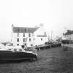
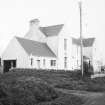
NR25NE 14.01 NR 25284 58340 Port Charlotte Hotel

NR25NE 14.02 NR 2528 5858 Museum of Islay Life

Activities

Field Visit (August 1977)

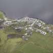
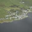
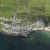
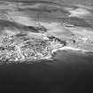
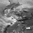
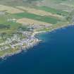
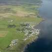
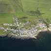
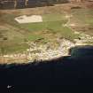
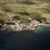
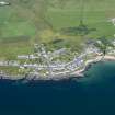
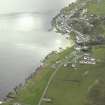
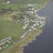
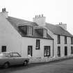
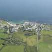
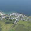
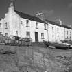
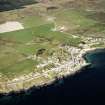
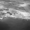
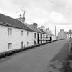
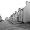
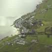
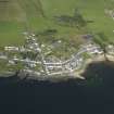
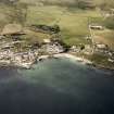
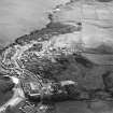
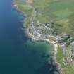
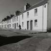
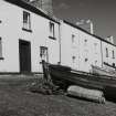
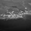
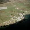
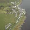
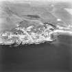
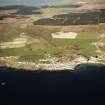
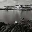
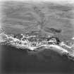
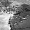
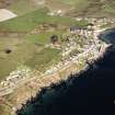
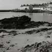
This well-preserved planned village was founded on the farm of Glassans by Walter Frederick Campbell of Islay in 1828, and was named in honour of his mother. Lady Charlotte Campbell.' Although occupying a coastal site on the w shore of Loch Indaal, the settlement was primarily agricultural in its original purpose and was partly intended to serve a distillery, which was established in 1829.

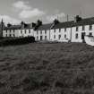
The remains of Lochindaal Distillery are situated at the N end of the village on the right bank of the Abhuinn Gearach, and groups of domestic buildings are arranged in a curvilinear pattern over a distance of about 500m on the w side of the highway which runs southwards to Portnahaven. At the centre of the village, terraced rows of houses are also grouped on the lower (E) side of this road and along the lanes leading down to and fronting the fore-shore; one of these lanes intersects the main road and continues its ascent westwards towards a former school-building and ultimately to Kilchiaran. Linear walled gardens are ranged behind the W properties, and the principal agricultural lots were originally

situated further to the W.

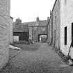
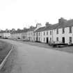
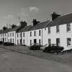
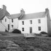
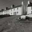
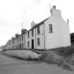
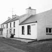
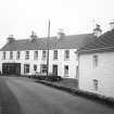
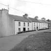
The houses are for the most part plain two-storeyed rectangular blocks of symmetrical three-bay design, whose frontages vary between about 8-7m and 10-1 m in width. They are constructed of harled or rendered limewashed rubble-masonry, and the majority have painted offset doorway-margins wrought with a simple chamfer. The first floor of one of the low-level houses on the E side of the main road is reached directly by a bridge, and a building with an external forestair stands near the shore at the S end of the village.

Visited August 1977

RCAHMS 1984

References

MyCanmore Image Contributions


Contribute an Image

MyCanmore Text Contributions