
Pricing Change
New pricing for orders of material from this site will come into place shortly. Charges for supply of digital images, digitisation on demand, prints and licensing will be altered.
Luing, Leccamore


Field Boundary (Post Medieval)(Possible)
Site Name Luing, Leccamore
Classification Field Boundary (Post Medieval)(Possible)
Canmore ID 372929
Site Number NM71SE 146
NGR NM 75137 10502
NGR Description Centre
Datum OSGB36 - NGR
Permalink http://canmore.org.uk/site/372929


- Council Argyll And Bute
- Parish Kilbrandon And Kilchattan
- Former Region Strathclyde
- Former District Argyll And Bute
- Former County Argyll
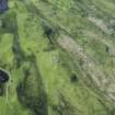
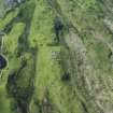
Airborne Laser Scanning Interpretation (27 January 2022)
NM71SW 155 75082 10496 to 75244 10546
This field boundary is evident on visualisations derived from Airborne Laser Scanning data 180m NE of Lochan Iliter. Presumably truncated by later activity, it climbs a slope in a SE direction for 40m before turning NE along a crest for 100m where it is interrupted by a track and quarry. It picks up a further 30m to the NE then turns sharply to the SE for a short distance.
Information from HES Archaeological Survey (Darroch Bratt) 27 January 2022

