
Pricing Change
New pricing for orders of material from this site will come into place shortly. Charges for supply of digital images, digitisation on demand, prints and licensing will be altered.
Luing, Leccamore


Quarry (Post Medieval)
Site Name Luing, Leccamore
Classification Quarry (Post Medieval)
Canmore ID 372897
Site Number NM71SE 130
NGR NM 75124 10877
NGR Description Centre
Datum OSGB36 - NGR
Permalink http://canmore.org.uk/site/372897


- Council Argyll And Bute
- Parish Kilbrandon And Kilchattan
- Former Region Strathclyde
- Former District Argyll And Bute
- Former County Argyll
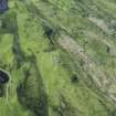
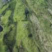
Airborne Laser Scanning Interpretation (26 January 2022)
NM71SE 130 75124 10877
A small quarry is evident on visualisations derived from Airborne Laser Scanning data about 90m NNE of Leccamore fort (NM71SE 2). Quarried material was presumably used in the drystone dyke that crosses the ridge about 30m to the NE.
Information from HES Archaeological Survey (Darroch Bratt) 26 January 2022

