
Luing, Camas Nan Gall


Hut (Post Medieval)
Site Name Luing, Camas Nan Gall
Classification Hut (Post Medieval)
Canmore ID 372743
Site Number NM70NW 117
NGR NM 73558 08049
NGR Description Centre
Datum OSGB36 - NGR
Permalink http://canmore.org.uk/site/372743


- Council Argyll And Bute
- Parish Kilbrandon And Kilchattan
- Former Region Strathclyde
- Former District Argyll And Bute
- Former County Argyll
Airborne Laser Scanning Interpretation (25 January 2022)
NM70NW 117 73557 08049
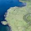
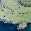
A hut is evident on visualisations derived from Airborne Laser Scanning at the foot of the cliff about 360m SE of Rowan Tree Cottage.
Information from HES Archaeological Survey (GF Geddes), 25 January 2022
ACFA No. 495

