
Pricing Change
New pricing for orders of material from this site will come into place shortly. Charges for supply of digital images, digitisation on demand, prints and licensing will be altered.
Luing, Tobair-na-suil


Field Boundary (Post Medieval), Pen (Post Medieval)
Site Name Luing, Tobair-na-suil
Classification Field Boundary (Post Medieval), Pen (Post Medieval)
Canmore ID 372640
Site Number NM71SE 72
NGR NM 75227 11587
NGR Description Centre
Datum OSGB36 - NGR
Permalink http://canmore.org.uk/site/372640


- Council Argyll And Bute
- Parish Kilbrandon And Kilchattan
- Former Region Strathclyde
- Former District Argyll And Bute
- Former County Argyll
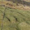
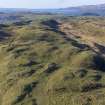
Field Visit (30 March 2022)
NM71SE 72 75182 11542 to 75257 11644
The remains of a grass-grown stone field boundary are evident on visualisations derived from Airborne Laser Scanning data about 120m NW of Tobar na Suil. Initially running from WSW to ENE, it climbs a steep slope for 28m before turning NNE to run along a break of slope for a further 80m and petering out. The boundary lines up with another 30m to the NE (NM71SE 98) that is shown on an estate map of 1847 (NRS, RHP571).
There is a small pen at NM 75224 11578 (ACFA 125) just 5m SE of this boundary.
Visited by HES Archaeological Survey (G Geddes and D Bratt), 30 March 2022 and 1 April 2022
ACFA No. 130

