 |
On-line Digital Images |
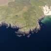
DP 112355 |
RCAHMS Aerial Photography Digital |
General oblique aerial view of fort at Dun Na Faing, Lossit Point, Islay, taken from the WSW. |
3/5/2011 |
Item Level |
|
 |
On-line Digital Images |
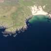
DP 112356 |
RCAHMS Aerial Photography Digital |
General oblique aerial view of Lossit Bay, taken from the W. |
3/5/2011 |
Item Level |
|
 |
On-line Digital Images |
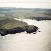
SC 1723730 |
RCAHMS Aerial Photography |
General oblique aerial view looking across the remains of the fort and Lossit Bay towards the S coast of Islay, taken from the NW. |
12/5/2005 |
Item Level |
|
 |
On-line Digital Images |
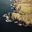
SC 1723731 |
RCAHMS Aerial Photography |
Oblique aerial view centred on the remains of the fort, taken from the SW. |
12/5/2005 |
Item Level |
|
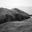 |
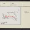
On-line Digital Images |
SC 2254370 |
Records of the Royal Commission on the Ancient and Historical Monuments of Scotland (RCAHMS), Edinbu |
RCAHMS |
1979 |
Item Level |
|
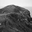 |
On-line Digital Images |
SC 2254371 |
Records of the Royal Commission on the Ancient and Historical Monuments of Scotland (RCAHMS), Edinbu |
RCAHMS |
1979 |
Item Level |
|
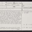 |
On-line Digital Images |
SC 2413325 |
Records of the Ordnance Survey, Southampton, Hampshire, England |
Islay, Lossit Point, Dun Na Faing, NR15NE 3, Ordnance Survey index card, page number 1, Recto |
1958 |
Item Level |
|
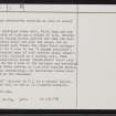 |
On-line Digital Images |
SC 2413326 |
Records of the Ordnance Survey, Southampton, Hampshire, England |
Islay, Lossit Point, Dun Na Faing, NR15NE 3, Ordnance Survey index card, page number 2, Recto |
1958 |
Item Level |
|
 |
On-line Digital Images |
SC 2413327 |
Records of the Ordnance Survey, Southampton, Hampshire, England |
Islay, Lossit Point, Dun Na Faing, NR15NE 3, Ordnance Survey index card, Recto |
1958 |
Item Level |
|
 |
On-line Digital Images |
SC 2413328 |
Records of the Ordnance Survey, Southampton, Hampshire, England |
Islay, Lossit Point, Dun Na Faing, NR15NE 3, Ordnance Survey index card, Recto |
1958 |
Item Level |
|


