|
Prints and Drawings |
DC 8098 PO |
Records of the Royal Commission on the Ancient and Historical Monuments of Scotland (RCAHMS), Edinbu |
NAS Antiquity model drawing. Photographic copy of drawing. |
|
Item Level |
|
|
Photographs and Off-line Digital Images |
KC 380 PO |
Records of the Society of Antiquaries of Scotland, Edinburgh, Scotland |
View of possible ring cairn.
Print card captioned: 'Stone circle next to south circle, looking towards Roman Camp.' |
|
Item Level |
|
 |
On-line Digital Images |
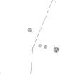
SC 342987 |
Records of the Royal Commission on the Ancient and Historical Monuments of Scotland (RCAHMS), Edinbu |
NAS Antiquity model drawing. Photographic copy of drawing. |
|
Item Level |
|
 |
On-line Digital Images |
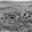
SC 682202 |
Records of the Society of Antiquaries of Scotland, Edinburgh, Scotland |
View of possible ring cairn.
Print card captioned: 'Stone circle next to south circle, looking towards Roman Camp.' |
|
Item Level |
|
|
Prints and Drawings |
DC 44577 |
Records of the Royal Commission on the Ancient and Historical Monuments of Scotland (RCAHMS), Edinbu |
RCAHMS survey drawing: Campstone Hill, Raedykes. Plan of ring-cairns NO89SW 6, 7, 8 & 9. |
15/4/2005 |
Item Level |
|
|
Manuscripts |
MS 36/177 |
Records of the Royal Commission on the Ancient and Historical Monuments of Scotland (RCAHMS), Edinbu |
Field notebook of K A Steer (RCAHMS). 'S10 - Forfar, Kincardine'. |
7/1956 |
Item Level |
|
 |
Digital Files (Non-image) |
WP 000776 |
Records of the Royal Commission on the Ancient and Historical Monuments of Scotland (RCAHMS), Edinbu |
Scanned copy of RCAHMS Marginal Land Survey unpublished typescripts (Kincardine-shire). |
1953 |
Item Level |
|
 |
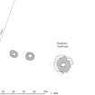
On-line Digital Images |
SC 1472649 |
|
RCAHMS survey drawing: Campstone Hill, Raedykes. Plan of ring-cairns NO89SW 6, 7, 8 & 9. |
15/4/2005 |
Item Level |
|
|
Digital Files (Non-image) |
GV 006375 |
Historic Environment Scotland |
HES Survey and Recording Illustration: Plan of Campstone Hill, Raedykes. |
1/2017 |
Item Level |
|
 |
On-line Digital Images |
SC 1556034 |
Historic Environment Scotland |
HES Survey and Recording Illustration: Plan of Campstone Hill, Raedykes. |
1/2017 |
Item Level |
|
 |
On-line Digital Images |
SC 2413153 |
Records of the Ordnance Survey, Southampton, Hampshire, England |
Campstone Hill, Raedykes, NO89SW 8, Ordnance Survey index card, Recto |
1958 |
Item Level |
|
 |
On-line Digital Images |
SC 2413154 |
Records of the Ordnance Survey, Southampton, Hampshire, England |
Campstone Hill, Raedykes, NO89SW 8, Ordnance Survey index card, Recto |
1958 |
Item Level |
|
 |
On-line Digital Images |
SC 2413155 |
Records of the Ordnance Survey, Southampton, Hampshire, England |
Campstone Hill, Raedykes, NO89SW 8, Ordnance Survey index card, Recto |
1958 |
Item Level |
|
|
All Other |
551 472/14/3 |
Audrey S Henshall |
Raedykes |
c. 1907 |
Batch Level |
|


