
Mid Gleniron


Consumption Dyke (19th Century)
Site Name Mid Gleniron
Classification Consumption Dyke (19th Century)
Canmore ID 371422
Site Number NX16SE 169
NGR NX 18668 61141
Datum OSGB36 - NGR
Permalink http://canmore.org.uk/site/371422


- Council Dumfries And Galloway
- Parish New Luce
- Former Region Dumfries And Galloway
- Former District Wigtown
- Former County Wigtownshire
Field Visit (23 March 2022)
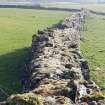
Situated in improved pasture 240m W of Mid Gleniron farmhouse there is a consumption dyke that measures 200m from N to S by up to 2.7m in maximum thickness and 2m in maximum height. The dyke follows an irregular path, suggesting a piecemeal construction, and in places the original outer face is hidden behind an addition skin of drystone walling. It is not depicted on the 1st edition of the OS 6-inch map but is shown on the 2nd edition of the 25-inch map (Wigtownshire 1894, Sheet XIII.13), and so probably dates to the latter part of the 19th century.
Visited by HES Archaeological Survey (J. Sherriff, L. Banaszek) 23 March 2022.

