|
Prints and Drawings |
DC 20113 |
Records of the Royal Commission on the Ancient and Historical Monuments of Scotland (RCAHMS), Edinbu |
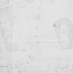
Survey drawings of two chambered cairns; plans of Blackhill Wood and Bruxie Hill. |
3/4/1982 |
Item Level |
|
|
Photographs and Off-line Digital Images |
KC 814 PO |
Records of Aberdeen Aerial Surveys, Aberdeen, Scotland |
Bruxie Hill, long cairn: oblique air photograph. |
28/7/1978 |
Item Level |
|
|
Photographs and Off-line Digital Images |
KC 815 PO |
Records of Aberdeen Aerial Surveys, Aberdeen, Scotland |
Bruxie Hill, long cairn: oblique air photograph. |
28/7/1978 |
Item Level |
|
|
Manuscripts |
MS 712/29 |
Records of Aberdeenshire Archaeology Service, Aberdeen, Scotland |
(Bound typescript A4) catalogue of photographs from Aberdeenshire Archaeological Service (formerly Grampian Regional Council) aerial reconnaissance, 1997. (Includes sites and monuments in Angus). |
1997 |
Item Level |
|
|
Photographs and Off-line Digital Images |
D 98080 PO |
Records of Aberdeen Aerial Surveys, Aberdeen, Scotland |
Bruxie Hill, long cairn: oblique air photograph. |
28/7/1978 |
Item Level |
|
|
Manuscripts |
MS 712/35 |
Records of Aberdeenshire Archaeology Service, Aberdeen, Scotland |
Photocopies of updates to Aberdeenshire Archaeological Service (formerly Grampian Regional Council) SMR, relating to sites, finds and monuments within area of former Grampian Region, received September 1998. |
1998 |
Item Level |
|
 |
On-line Digital Images |
SC 1817214 |
Records of the Royal Commission on the Ancient and Historical Monuments of Scotland (RCAHMS), Edinbu |
Survey drawings of two chambered cairns; plans of Blackhill Wood and Bruxie Hill. Scanned copy. |
3/4/1982 |
Item Level |
|
 |
On-line Digital Images |
SC 2412918 |
Records of the Ordnance Survey, Southampton, Hampshire, England |
Bruxie Hill, NO88SW 21, Ordnance Survey index card, page number 1, Recto |
c. 1958 |
Item Level |
|
 |
On-line Digital Images |
SC 2412919 |
Records of the Ordnance Survey, Southampton, Hampshire, England |
Bruxie Hill, NO88SW 21, Ordnance Survey index card, Recto |
c. 1958 |
Item Level |
|


