
Bowduns


Boundary Bank(S) (Period Unassigned)
Site Name Bowduns
Classification Boundary Bank(S) (Period Unassigned)
Canmore ID 37010
Site Number NO88SE 3
NGR NO 8813 8453
Datum OSGB36 - NGR
Permalink http://canmore.org.uk/site/37010


- Council Aberdeenshire
- Parish Dunnottar
- Former Region Grampian
- Former District Kincardine And Deeside
- Former County Kincardineshire
NO88SE 3 8813 8453.
(NO 8813 8453) Bowduns (NAT) Rampart (NR) (Remains of)
OS 6" map, Kincardineshire, 2nd ed., (1904)
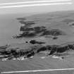
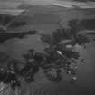
Bowduns is said to be a corruption of 'Bri-dun' - 'the high fort'. The headland is cut off by a small ravine, at the bottom of which runs a bank 6ft wide and 1 to 2ft high. A similar bank runs along the eastern lip of the ravine.
It seemed to Christison (1899) that these banks were fences rather than defensive ramparts.
The whole of the peninsular has been ploughed, with the exception of the extremities jutting seaward.
Name Book 1865; D Christison 1899; OS 6" map annotated by O G S Crawford, 1 November 1939.
The promontory of Bowduns is not a good defensive position, and is unlikely to be the site of a fort. The small ravine is no more than a shallow dip at the neck of the promontory, and apart from the slight bank which runs along the centre of the dip, and a slight bank around the NW edge of the the promontory, which both appear to be cultivation or enclosure banks, there is no trace of any ramparts or fortification on or around the site.
Visited by OS (R D) 23 July 1965.

