
Burnfield Road, Thornliebank


No Class (Event) (Period Unassigned)
Site Name Burnfield Road, Thornliebank
Classification No Class (Event) (Period Unassigned)
Canmore ID 369754
Site Number NS56SE 2373
NGR NS 55341 60039
Datum OSGB36 - NGR
Permalink http://canmore.org.uk/site/369754
Ordnance Survey licence number AC0000807262. All rights reserved.
Canmore Disclaimer.
© Bluesky International Limited 2025. Public Sector Viewing Terms
- Correction
- Favourite

DP 416146
Watching Brief photograph, South facing section, Rooms B-C (20.00 -22.00m), Taken from, Burnfield Road, Thornliebank, Glasgow
Records from GUARD Archaeology Ltd, archaeologists, Glasgow, Scotland
29/9/2020
© Copyright: GUARD Archaeology Ltd.. Courtesy of HES.

DP 416153
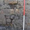
Watching Brief photograph, Detail of chain in Stable (Room C), Taken from N, Burnfield Road, Thornliebank, Glasgow
Records from GUARD Archaeology Ltd, archaeologists, Glasgow, Scotland
29/9/2020
© Copyright: GUARD Archaeology Ltd.. Courtesy of HES.

DP 416203
Evaluation photograph, Location, Taken from SW, Burnfield Road, Thornliebank, Glasgow
Records from GUARD Archaeology Ltd, archaeologists, Glasgow, Scotland
15/8/2018
© Copyright: GUARD Archaeology Ltd.. Courtesy of HES.

DP 416181
Watching Brief photograph, Detail of double fire, Taken from W, Burnfield Road, Thornliebank, Glasgow
Records from GUARD Archaeology Ltd, archaeologists, Glasgow, Scotland
30/9/2020
© Copyright: GUARD Archaeology Ltd.. Courtesy of HES.

DP 416185
Watching Brief photograph, General view of original building, Taken from NW, Burnfield Road, Thornliebank, Glasgow
Records from GUARD Archaeology Ltd, archaeologists, Glasgow, Scotland
30/9/2020
© Copyright: GUARD Archaeology Ltd.. Courtesy of HES.

DP 416190
Watching Brief photograph, Post demolition shot, Taken from E, Burnfield Road, Thornliebank, Glasgow
Records from GUARD Archaeology Ltd, archaeologists, Glasgow, Scotland
30/9/2020
© Copyright: GUARD Archaeology Ltd.. Courtesy of HES.

DP 416195
Watching Brief photograph, Post strip area, Taken from E, Burnfield Road, Thornliebank, Glasgow
Records from GUARD Archaeology Ltd, archaeologists, Glasgow, Scotland
30/9/2020
© Copyright: GUARD Archaeology Ltd.. Courtesy of HES.

DP 416214
Evaluation photograph, Location, Taken from SE, Burnfield Road, Thornliebank, Glasgow
Records from GUARD Archaeology Ltd, archaeologists, Glasgow, Scotland
15/8/2018
© Copyright: GUARD Archaeology Ltd.. Courtesy of HES.

DP 416221
Evaluation photograph, General site shot, Burnfield Road, Thornliebank, Glasgow
Records from GUARD Archaeology Ltd, archaeologists, Glasgow, Scotland
15/8/2018
© Copyright: GUARD Archaeology Ltd.. Courtesy of HES.

DP 416155
Watching Brief photograph, General view of stable ground, Taken from W, Burnfield Road, Thornliebank, Glasgow
Records from GUARD Archaeology Ltd, archaeologists, Glasgow, Scotland
29/9/2020
© Copyright: GUARD Archaeology Ltd.. Courtesy of HES.

DP 416202
Evaluation photograph, Post ext. plan of trench, Taken from SW, Burnfield Road, Thornliebank, Glasgow
Records from GUARD Archaeology Ltd, archaeologists, Glasgow, Scotland
15/8/2018
© Copyright: GUARD Archaeology Ltd.. Courtesy of HES.
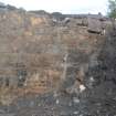
![Watching Brief photograph, North facing section [400], Rooms C - D (20.00 to 22.00 m), Taken from N, Burnfield Road, Thornliebank, Glasgow](http://i.rcahms.gov.uk/canmore/l/DP00416176.jpg)
DP 416176
Watching Brief photograph, North facing section [400], Rooms C - D (20.00 to 22.00 m), Taken from N, Burnfield Road, Thornliebank, Glasgow
Records from GUARD Archaeology Ltd, archaeologists, Glasgow, Scotland
30/9/2020
© Copyright: GUARD Archaeology Ltd.. Courtesy of HES.
![Watching Brief photograph, North facing section [400], Rooms C - D (22.00 to 24.00 m), Taken from N, Burnfield Road, Thornliebank, Glasgow](http://i.rcahms.gov.uk/canmore/l/DP00416177.jpg)
DP 416177
Watching Brief photograph, North facing section [400], Rooms C - D (22.00 to 24.00 m), Taken from N, Burnfield Road, Thornliebank, Glasgow
Records from GUARD Archaeology Ltd, archaeologists, Glasgow, Scotland
30/9/2020
© Copyright: GUARD Archaeology Ltd.. Courtesy of HES.

DP 416154
Watching Brief photograph, Detail of stable stone for animals, Taken from S, Burnfield Road, Thornliebank, Glasgow
Records from GUARD Archaeology Ltd, archaeologists, Glasgow, Scotland
29/9/2020
© Copyright: GUARD Archaeology Ltd.. Courtesy of HES.
![Watching Brief photograph, North facing section [400], Rooms C - D (6.00 to 8.00 m), Taken from N, Burnfield Road, Thornliebank, Glasgow](http://i.rcahms.gov.uk/canmore/l/DP00416169.jpg)
DP 416169
Watching Brief photograph, North facing section [400], Rooms C - D (6.00 to 8.00 m), Taken from N, Burnfield Road, Thornliebank, Glasgow
Records from GUARD Archaeology Ltd, archaeologists, Glasgow, Scotland
30/9/2020
© Copyright: GUARD Archaeology Ltd.. Courtesy of HES.
![Watching Brief photograph, North facing section [400], Rooms C - D (18.00 to 20.00 m), Taken from N, Burnfield Road, Thornliebank, Glasgow](http://i.rcahms.gov.uk/canmore/l/DP00416175.jpg)
DP 416175
Watching Brief photograph, North facing section [400], Rooms C - D (18.00 to 20.00 m), Taken from N, Burnfield Road, Thornliebank, Glasgow
Records from GUARD Archaeology Ltd, archaeologists, Glasgow, Scotland
30/9/2020
© Copyright: GUARD Archaeology Ltd.. Courtesy of HES.
![Watching Brief photograph, North facing section [400], Rooms C - D (26.00 to 28.00 m), Taken from N, Burnfield Road, Thornliebank, Glasgow](http://i.rcahms.gov.uk/canmore/l/DP00416179.jpg)
DP 416179
Watching Brief photograph, North facing section [400], Rooms C - D (26.00 to 28.00 m), Taken from N, Burnfield Road, Thornliebank, Glasgow
Records from GUARD Archaeology Ltd, archaeologists, Glasgow, Scotland
30/9/2020
© Copyright: GUARD Archaeology Ltd.. Courtesy of HES.

DP 416184
Watching Brief photograph, Shot of original building post-excavation, NW corner, Taken from NW, Burnfield Road, Thornliebank, Glasgow
Records from GUARD Archaeology Ltd, archaeologists, Glasgow, Scotland
30/9/2020
© Copyright: GUARD Archaeology Ltd.. Courtesy of HES.
![Watching Brief photograph, West facing section [500], Room A (4.00 -7.00 m), Taken from W, Burnfield Road, Thornliebank, Glasgow](http://i.rcahms.gov.uk/canmore/l/DP00416189.jpg)
DP 416189
Watching Brief photograph, West facing section [500], Room A (4.00 -7.00 m), Taken from W, Burnfield Road, Thornliebank, Glasgow
Records from GUARD Archaeology Ltd, archaeologists, Glasgow, Scotland
30/9/2020
© Copyright: GUARD Archaeology Ltd.. Courtesy of HES.

DP 416193
Watching Brief photograph, Post strip area, Taken from NW, Burnfield Road, Thornliebank, Glasgow
Records from GUARD Archaeology Ltd, archaeologists, Glasgow, Scotland
30/9/2020
© Copyright: GUARD Archaeology Ltd.. Courtesy of HES.

DP 416205
Records from GUARD Archaeology Ltd, archaeologists, Glasgow, Scotland
15/8/2018
© Copyright: GUARD Archaeology Ltd.. Courtesy of HES.

DP 416208
Evaluation photograph, Trench location, Taken from NE, Burnfield Road, Thornliebank, Glasgow
Records from GUARD Archaeology Ltd, archaeologists, Glasgow, Scotland
15/8/2018
© Copyright: GUARD Archaeology Ltd.. Courtesy of HES.

DP 416215
Evaluation photograph, NW facing section, Taken from NW, Burnfield Road, Thornliebank, Glasgow
Records from GUARD Archaeology Ltd, archaeologists, Glasgow, Scotland
15/8/2018
© Copyright: GUARD Archaeology Ltd.. Courtesy of HES.
![Watching Brief photograph, North facing section [400], Rooms C - D (10.00 to 12.00 m), Taken from N, Burnfield Road, Thornliebank, Glasgow](http://i.rcahms.gov.uk/canmore/l/DP00416171.jpg)
DP 416171
Watching Brief photograph, North facing section [400], Rooms C - D (10.00 to 12.00 m), Taken from N, Burnfield Road, Thornliebank, Glasgow
Records from GUARD Archaeology Ltd, archaeologists, Glasgow, Scotland
30/9/2020
© Copyright: GUARD Archaeology Ltd.. Courtesy of HES.
![Watching Brief photograph, North facing section [400], Rooms C - D (16.00 to 18.00 m), Taken from N, Burnfield Road, Thornliebank, Glasgow](http://i.rcahms.gov.uk/canmore/l/DP00416174.jpg)
DP 416174
Watching Brief photograph, North facing section [400], Rooms C - D (16.00 to 18.00 m), Taken from N, Burnfield Road, Thornliebank, Glasgow
Records from GUARD Archaeology Ltd, archaeologists, Glasgow, Scotland
30/9/2020
© Copyright: GUARD Archaeology Ltd.. Courtesy of HES.
![Watching Brief photograph, North facing section [400], Rooms C - D (24.00 to 26.00 m), Taken from N, Burnfield Road, Thornliebank, Glasgow](http://i.rcahms.gov.uk/canmore/l/DP00416178.jpg)
DP 416178
Watching Brief photograph, North facing section [400], Rooms C - D (24.00 to 26.00 m), Taken from N, Burnfield Road, Thornliebank, Glasgow
Records from GUARD Archaeology Ltd, archaeologists, Glasgow, Scotland
30/9/2020
© Copyright: GUARD Archaeology Ltd.. Courtesy of HES.

DP 416182
Watching Brief photograph, Shot of original building post-excavation, SW corner, Taken from SW, Burnfield Road, Thornliebank, Glasgow
Records from GUARD Archaeology Ltd, archaeologists, Glasgow, Scotland
30/9/2020
© Copyright: GUARD Archaeology Ltd.. Courtesy of HES.
![Watching Brief photograph, West facing section of [500], Taken from W, Burnfield Road, Thornliebank, Glasgow](http://i.rcahms.gov.uk/canmore/l/DP00416183.jpg)
DP 416183
Watching Brief photograph, West facing section of [500], Taken from W, Burnfield Road, Thornliebank, Glasgow
Records from GUARD Archaeology Ltd, archaeologists, Glasgow, Scotland
30/9/2020
© Copyright: GUARD Archaeology Ltd.. Courtesy of HES.

DP 416191
Watching Brief photograph, Post strip, East area, Taken from E, Burnfield Road, Thornliebank, Glasgow
Records from GUARD Archaeology Ltd, archaeologists, Glasgow, Scotland
30/9/2020
© Copyright: GUARD Archaeology Ltd.. Courtesy of HES.

DP 416194
Watching Brief photograph, Post strip area, Taken from W, Burnfield Road, Thornliebank, Glasgow
Records from GUARD Archaeology Ltd, archaeologists, Glasgow, Scotland
30/9/2020
© Copyright: GUARD Archaeology Ltd.. Courtesy of HES.

DP 416211
Evaluation photograph, Trench location, Taken from NE, Burnfield Road, Thornliebank, Glasgow
Records from GUARD Archaeology Ltd, archaeologists, Glasgow, Scotland
15/8/2018
© Copyright: GUARD Archaeology Ltd.. Courtesy of HES.

DP 416212
Evaluation photograph, NW facing section, Taken from NW, Burnfield Road, Thornliebank, Glasgow
Records from GUARD Archaeology Ltd, archaeologists, Glasgow, Scotland
15/8/2018
© Copyright: GUARD Archaeology Ltd.. Courtesy of HES.

DP 416217
Evaluation photograph, General site shot, Burnfield Road, Thornliebank, Glasgow
Records from GUARD Archaeology Ltd, archaeologists, Glasgow, Scotland
15/8/2018
© Copyright: GUARD Archaeology Ltd.. Courtesy of HES.

DP 416141
Watching Brief photograph, Rooms A - B, South facing section (10.00 - 12.00 m), Taken from S, Burnfield Road, Thornliebank, Glasgow
Records from GUARD Archaeology Ltd, archaeologists, Glasgow, Scotland
29/9/2020
© Copyright: GUARD Archaeology Ltd.. Courtesy of HES.

DP 416151
Watching Brief photograph, South facing section, Rom D (30.00 -32.00m), Taken from S, Burnfield Road, Thornliebank, Glasgow
Records from GUARD Archaeology Ltd, archaeologists, Glasgow, Scotland
29/9/2020
© Copyright: GUARD Archaeology Ltd.. Courtesy of HES.
![Watching Brief photograph, North facing section [400], Rooms C - D (2.00 to 4.00 m), Taken from N, Burnfield Road, Thornliebank, Glasgow](http://i.rcahms.gov.uk/canmore/l/DP00416167.jpg)
DP 416167
Watching Brief photograph, North facing section [400], Rooms C - D (2.00 to 4.00 m), Taken from N, Burnfield Road, Thornliebank, Glasgow
Records from GUARD Archaeology Ltd, archaeologists, Glasgow, Scotland
30/9/2020
© Copyright: GUARD Archaeology Ltd.. Courtesy of HES.
![Watching Brief photograph, North facing section [400], Rooms C - D (28.00 to 30.00 m), Taken from N, Burnfield Road, Thornliebank, Glasgow](http://i.rcahms.gov.uk/canmore/l/DP00416180.jpg)
DP 416180
Watching Brief photograph, North facing section [400], Rooms C - D (28.00 to 30.00 m), Taken from N, Burnfield Road, Thornliebank, Glasgow
Records from GUARD Archaeology Ltd, archaeologists, Glasgow, Scotland
30/9/2020
© Copyright: GUARD Archaeology Ltd.. Courtesy of HES.

DP 416186
Watching Brief photograph, Demolition work, Taken from NW, Burnfield Road, Thornliebank, Glasgow
Records from GUARD Archaeology Ltd, archaeologists, Glasgow, Scotland
30/9/2020
© Copyright: GUARD Archaeology Ltd.. Courtesy of HES.

DP 416207
Records from GUARD Archaeology Ltd, archaeologists, Glasgow, Scotland
15/8/2018
© Copyright: GUARD Archaeology Ltd.. Courtesy of HES.

DP 416219
Evaluation photograph, NE facing section, Taken from NE, Burnfield Road, Thornliebank, Glasgow
Records from GUARD Archaeology Ltd, archaeologists, Glasgow, Scotland
15/8/2018
© Copyright: GUARD Archaeology Ltd.. Courtesy of HES.

DP 416222
Evaluation photograph, General site shot, Burnfield Road, Thornliebank, Glasgow
Records from GUARD Archaeology Ltd, archaeologists, Glasgow, Scotland
15/8/2018
© Copyright: GUARD Archaeology Ltd.. Courtesy of HES.

DP 416152
Watching Brief photograph, General view of south facing section, Taken from SE, Burnfield Road, Thornliebank, Glasgow
Records from GUARD Archaeology Ltd, archaeologists, Glasgow, Scotland
29/9/2020
© Copyright: GUARD Archaeology Ltd.. Courtesy of HES.

DP 416204
Evaluation photograph, NE facing section, Taken from NE, Burnfield Road, Thornliebank, Glasgow
Records from GUARD Archaeology Ltd, archaeologists, Glasgow, Scotland
15/8/2018
© Copyright: GUARD Archaeology Ltd.. Courtesy of HES.
![Watching Brief photograph, North facing section [400], Rooms C - D (8.00 to 10.00 m), Taken from N, Burnfield Road, Thornliebank, Glasgow](http://i.rcahms.gov.uk/canmore/l/DP00416170.jpg)
DP 416170
Watching Brief photograph, North facing section [400], Rooms C - D (8.00 to 10.00 m), Taken from N, Burnfield Road, Thornliebank, Glasgow
Records from GUARD Archaeology Ltd, archaeologists, Glasgow, Scotland
30/9/2020
© Copyright: GUARD Archaeology Ltd.. Courtesy of HES.
![Watching Brief photograph, North facing section [400], Rooms C - D (12.00 to 14.00 m), Taken from N, Burnfield Road, Thornliebank, Glasgow](http://i.rcahms.gov.uk/canmore/l/DP00416172.jpg)
DP 416172
Watching Brief photograph, North facing section [400], Rooms C - D (12.00 to 14.00 m), Taken from N, Burnfield Road, Thornliebank, Glasgow
Records from GUARD Archaeology Ltd, archaeologists, Glasgow, Scotland
30/9/2020
© Copyright: GUARD Archaeology Ltd.. Courtesy of HES.
![Watching Brief photograph, North facing section [400], Rooms C - D (14.00 to 16.00 m), Taken from N, Burnfield Road, Thornliebank, Glasgow](http://i.rcahms.gov.uk/canmore/l/DP00416173.jpg)
DP 416173
Watching Brief photograph, North facing section [400], Rooms C - D (14.00 to 16.00 m), Taken from N, Burnfield Road, Thornliebank, Glasgow
Records from GUARD Archaeology Ltd, archaeologists, Glasgow, Scotland
30/9/2020
© Copyright: GUARD Archaeology Ltd.. Courtesy of HES.

DP 416223
Evaluation photograph, Location, Taken from NE, Burnfield Road, Thornliebank, Glasgow
Records from GUARD Archaeology Ltd, archaeologists, Glasgow, Scotland
15/8/2018
© Copyright: GUARD Archaeology Ltd.. Courtesy of HES.

DP 416225
Evaluation photograph, S facing section, Taken from S, Burnfield Road, Thornliebank, Glasgow
Records from GUARD Archaeology Ltd, archaeologists, Glasgow, Scotland
15/8/2018
© Copyright: GUARD Archaeology Ltd.. Courtesy of HES.

DP 416150
Watching Brief photograph, South facing section, Rooms C-D (28.00 -30.00m), Taken from S, Burnfield Road, Thornliebank, Glasgow
Records from GUARD Archaeology Ltd, archaeologists, Glasgow, Scotland
29/9/2020
© Copyright: GUARD Archaeology Ltd.. Courtesy of HES.
![Watching Brief photograph, North facing section [400], Rooms C - D (-2 to 0 m), Taken from N, Burnfield Road, Thornliebank, Glasgow](http://i.rcahms.gov.uk/canmore/l/DP00416165.jpg)
DP 416165
Watching Brief photograph, North facing section [400], Rooms C - D (-2 to 0 m), Taken from N, Burnfield Road, Thornliebank, Glasgow
Records from GUARD Archaeology Ltd, archaeologists, Glasgow, Scotland
30/9/2020
© Copyright: GUARD Archaeology Ltd.. Courtesy of HES.
![Watching Brief photograph, North facing section [400], Rooms C - D (0 to 2.00 m), Taken from N, Burnfield Road, Thornliebank, Glasgow](http://i.rcahms.gov.uk/canmore/l/DP00416166.jpg)
DP 416166
Watching Brief photograph, North facing section [400], Rooms C - D (0 to 2.00 m), Taken from N, Burnfield Road, Thornliebank, Glasgow
Records from GUARD Archaeology Ltd, archaeologists, Glasgow, Scotland
30/9/2020
© Copyright: GUARD Archaeology Ltd.. Courtesy of HES.
![Watching Brief photograph, West facing section [500], Room A (0 -2.00 m), Taken from W, Burnfield Road, Thornliebank, Glasgow](http://i.rcahms.gov.uk/canmore/l/DP00416187.jpg)
DP 416187
Watching Brief photograph, West facing section [500], Room A (0 -2.00 m), Taken from W, Burnfield Road, Thornliebank, Glasgow
Records from GUARD Archaeology Ltd, archaeologists, Glasgow, Scotland
30/9/2020
© Copyright: GUARD Archaeology Ltd.. Courtesy of HES.

DP 416206
Evaluation photograph, SW facing section, Taken from NE, Burnfield Road, Thornliebank, Glasgow
Records from GUARD Archaeology Ltd, archaeologists, Glasgow, Scotland
15/8/2018
© Copyright: GUARD Archaeology Ltd.. Courtesy of HES.

DP 416209
Evaluation photograph, S facing section, Taken from S, Burnfield Road, Thornliebank, Glasgow
Records from GUARD Archaeology Ltd, archaeologists, Glasgow, Scotland
15/8/2018
© Copyright: GUARD Archaeology Ltd.. Courtesy of HES.

DP 416218
Evaluation photograph, Location, Taken from NW, Burnfield Road, Thornliebank, Glasgow
Records from GUARD Archaeology Ltd, archaeologists, Glasgow, Scotland
15/8/2018
© Copyright: GUARD Archaeology Ltd.. Courtesy of HES.

DP 416220
Records from GUARD Archaeology Ltd, archaeologists, Glasgow, Scotland
15/8/2018
© Copyright: GUARD Archaeology Ltd.. Courtesy of HES.
![Watching Brief photograph, North facing section [400], Rooms C - D (4.00 to 6.00 m), Taken from N, Burnfield Road, Thornliebank, Glasgow](http://i.rcahms.gov.uk/canmore/l/DP00416168.jpg)
DP 416168
Watching Brief photograph, North facing section [400], Rooms C - D (4.00 to 6.00 m), Taken from N, Burnfield Road, Thornliebank, Glasgow
Records from GUARD Archaeology Ltd, archaeologists, Glasgow, Scotland
30/9/2020
© Copyright: GUARD Archaeology Ltd.. Courtesy of HES.
![Watching Brief photograph, West facing section [500], Room A (2.00 -4.00 m), Taken from W, Burnfield Road, Thornliebank, Glasgow](http://i.rcahms.gov.uk/canmore/l/DP00416188.jpg)
DP 416188
Watching Brief photograph, West facing section [500], Room A (2.00 -4.00 m), Taken from W, Burnfield Road, Thornliebank, Glasgow
Records from GUARD Archaeology Ltd, archaeologists, Glasgow, Scotland
30/9/2020
© Copyright: GUARD Archaeology Ltd.. Courtesy of HES.

DP 416192
Watching Brief photograph, Machine works, Taken from E, Burnfield Road, Thornliebank, Glasgow
Records from GUARD Archaeology Ltd, archaeologists, Glasgow, Scotland
30/9/2020
© Copyright: GUARD Archaeology Ltd.. Courtesy of HES.

DP 416216
Records from GUARD Archaeology Ltd, archaeologists, Glasgow, Scotland
15/8/2018
© Copyright: GUARD Archaeology Ltd.. Courtesy of HES.
![Watching Brief photograph, North facing section [400], Rooms C - D (20.00 to 22.00 m), Taken from N, Burnfield Road, Thornliebank, Glasgow](http://i.rcahms.gov.uk/canmore/s/DP00416176.jpg)
![Watching Brief photograph, North facing section [400], Rooms C - D (22.00 to 24.00 m), Taken from N, Burnfield Road, Thornliebank, Glasgow](http://i.rcahms.gov.uk/canmore/s/DP00416177.jpg)
![Watching Brief photograph, North facing section [400], Rooms C - D (6.00 to 8.00 m), Taken from N, Burnfield Road, Thornliebank, Glasgow](http://i.rcahms.gov.uk/canmore/s/DP00416169.jpg)
![Watching Brief photograph, North facing section [400], Rooms C - D (18.00 to 20.00 m), Taken from N, Burnfield Road, Thornliebank, Glasgow](http://i.rcahms.gov.uk/canmore/s/DP00416175.jpg)
![Watching Brief photograph, North facing section [400], Rooms C - D (26.00 to 28.00 m), Taken from N, Burnfield Road, Thornliebank, Glasgow](http://i.rcahms.gov.uk/canmore/s/DP00416179.jpg)
![Watching Brief photograph, West facing section [500], Room A (4.00 -7.00 m), Taken from W, Burnfield Road, Thornliebank, Glasgow](http://i.rcahms.gov.uk/canmore/s/DP00416189.jpg)
![Watching Brief photograph, North facing section [400], Rooms C - D (10.00 to 12.00 m), Taken from N, Burnfield Road, Thornliebank, Glasgow](http://i.rcahms.gov.uk/canmore/s/DP00416171.jpg)
![Watching Brief photograph, North facing section [400], Rooms C - D (16.00 to 18.00 m), Taken from N, Burnfield Road, Thornliebank, Glasgow](http://i.rcahms.gov.uk/canmore/s/DP00416174.jpg)
![Watching Brief photograph, North facing section [400], Rooms C - D (24.00 to 26.00 m), Taken from N, Burnfield Road, Thornliebank, Glasgow](http://i.rcahms.gov.uk/canmore/s/DP00416178.jpg)
![Watching Brief photograph, West facing section of [500], Taken from W, Burnfield Road, Thornliebank, Glasgow](http://i.rcahms.gov.uk/canmore/s/DP00416183.jpg)
![Watching Brief photograph, North facing section [400], Rooms C - D (2.00 to 4.00 m), Taken from N, Burnfield Road, Thornliebank, Glasgow](http://i.rcahms.gov.uk/canmore/s/DP00416167.jpg)
![Watching Brief photograph, North facing section [400], Rooms C - D (28.00 to 30.00 m), Taken from N, Burnfield Road, Thornliebank, Glasgow](http://i.rcahms.gov.uk/canmore/s/DP00416180.jpg)
![Watching Brief photograph, North facing section [400], Rooms C - D (8.00 to 10.00 m), Taken from N, Burnfield Road, Thornliebank, Glasgow](http://i.rcahms.gov.uk/canmore/s/DP00416170.jpg)
![Watching Brief photograph, North facing section [400], Rooms C - D (12.00 to 14.00 m), Taken from N, Burnfield Road, Thornliebank, Glasgow](http://i.rcahms.gov.uk/canmore/s/DP00416172.jpg)
![Watching Brief photograph, North facing section [400], Rooms C - D (14.00 to 16.00 m), Taken from N, Burnfield Road, Thornliebank, Glasgow](http://i.rcahms.gov.uk/canmore/s/DP00416173.jpg)

![Watching Brief photograph, North facing section [400], Rooms C - D (-2 to 0 m), Taken from N, Burnfield Road, Thornliebank, Glasgow](http://i.rcahms.gov.uk/canmore/s/DP00416165.jpg)
![Watching Brief photograph, North facing section [400], Rooms C - D (0 to 2.00 m), Taken from N, Burnfield Road, Thornliebank, Glasgow](http://i.rcahms.gov.uk/canmore/s/DP00416166.jpg)
![Watching Brief photograph, West facing section [500], Room A (0 -2.00 m), Taken from W, Burnfield Road, Thornliebank, Glasgow](http://i.rcahms.gov.uk/canmore/s/DP00416187.jpg)
![Watching Brief photograph, North facing section [400], Rooms C - D (4.00 to 6.00 m), Taken from N, Burnfield Road, Thornliebank, Glasgow](http://i.rcahms.gov.uk/canmore/s/DP00416168.jpg)
![Watching Brief photograph, West facing section [500], Room A (2.00 -4.00 m), Taken from W, Burnfield Road, Thornliebank, Glasgow](http://i.rcahms.gov.uk/canmore/s/DP00416188.jpg)
- Council Glasgow, City Of
- Parish Eastwood (City Of Glasgow)
- Former Region Strathclyde
- Former District City Of Glasgow
- Former County Lanarkshire
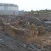
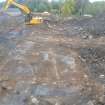
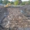
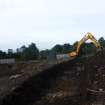
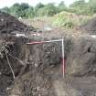
Archaeological Evaluation (15 August 2018)
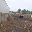
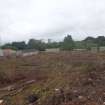
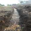
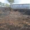
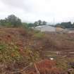
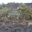
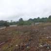
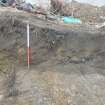
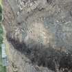
NS 55341 60039 (centred) An evaluation was undertaken at Burnfield Road, Thornliebank, on 15 August 2018. A series of evaluation trial trenches equating to 9% (ie 570m²) of the total area available was undertaken. A total of seven trenches were excavated across the available area and no archaeological features were uncovered, though an area of modern dump material was encountered along the western edge of the site.
Archive: NRHE
Funder: Bellway Homes
Jamie Henderson – GUARD
(Source: DES Vol 21)
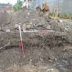
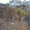
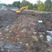
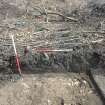
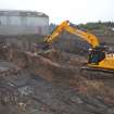
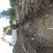
Watching Brief (28 September 2020 - 30 September 2020)
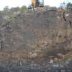
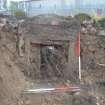
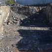
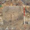
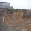
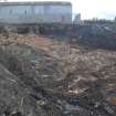
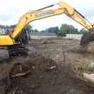
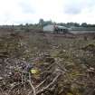
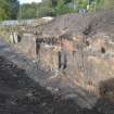
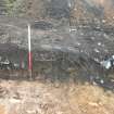
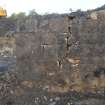
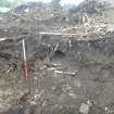
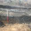
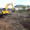
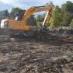
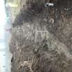
NS 55341 60039 GUARD Archaeology Limited were commissioned by Bellway Homes to undertake an archaeological watching brief, following a previous evaluation, during the construction work related to the proposed development at Burnfield Road, Thornliebank, Glasgow. This work was undertaken between 28 and 30 September 2020 and revealed remains related to a farmstead building known as Burnfield within the parameters of the site.
Information from Iraia Arabaolaza - GUARD Archaeology Limited.

