
Following the launch of trove.scot in February 2025 we are now planning the retiral of some of our webservices. Canmore will be switched off on 24th June 2025. Information about the closure can be found on the HES website: Retiral of HES web services | Historic Environment Scotland
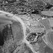
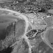
Stonehaven, Cowie Bridge


Road Bridge (Period Unassigned)
Site Name Stonehaven, Cowie Bridge
Classification Road Bridge (Period Unassigned)
Alternative Name(s) Cowie Water; Bridge Of Cowie
Canmore ID 36946
Site Number NO88NE 61
NGR NO 87372 86308
Datum OSGB36 - NGR
Permalink http://canmore.org.uk/site/36946


- Council Aberdeenshire
- Parish Fetteresso
- Former Region Grampian
- Former District Kincardine And Deeside
- Former County Kincardineshire
NO88NE 61 87372 86308
Cowie Bridge [NAT]
OS (GIS) MasterMap, October 2010.
For associated WWII military defence works, see NO88NE 312.
NMRS REFERENCE:
Cowie Bridge.
Architect: William Adam. Bridge over Cowie Water, Stonehaven, 1732.
(Caledonian Mercury, June 27th 1732).
(Undated) information in NMRS.

