Accessibility

Font Size

100% 150% 200%

Background Colour

Default Contrast
Close Reset

Stonehaven, General

Burgh (Medieval), Town (Period Unassigned)

Site Name Stonehaven, General

Classification Burgh (Medieval), Town (Period Unassigned)

Canmore ID 36934

Site Number NO88NE 52

NGR NO 8729 8600

NGR Description Centred NO 8729 8600

Datum OSGB36 - NGR

Permalink http://canmore.org.uk/site/36934

Ordnance Survey licence number AC0000807262. All rights reserved.
Canmore Disclaimer. © Bluesky International Limited 2025. Public Sector Viewing Terms

Toggle Aerial | View on large map

Digital Images

Oblique aerial view centred on the market buildings and hotel, taken from the ESE.
Oblique aerial view centred on the market buildings and hotel, taken from the ESE.General oblique aerial view of the town of Stonehaven, taken from the W.Old Town Stonehaven . Student undergraduate final year thesis drawings.
Dundee School of Architecture.
Section A - A , B - B & C - C. Site elevations.Oblique aerial view centred on Stonehaven harbour, looking to the S.Oblique aerial view centred on the cropmarks of the unenclosed settlement and field system at Braehead with Stonehaven adjacent, looking to the ESE.Oblique aerial view centred on the harbour, taken from the SSW.Oblique aerial view centred on the harbour, taken from the SE.General oblique aerial view of the town of Stonehaven, taken from the W.View of 'Bathing Woman' in Stonehaven.General View Dunnottar, Kincardineshire, Scotland. Oblique aerial photograph taken facing North/West. Oblique aerial view with Cowie in the foreground and Stonehaven beyond, looking to the SSW.Oblique aerial view of Stonehaven and Stonehaven Harbour, looking WSW.General View Dunnottar, Kincardineshire, Scotland. Oblique aerial photograph taken facing North/West. Oblique aerial view centred on Stonehaven harbour, looking to the S.Stonehaven, General, NO88NE 52, Ordnance Survey index card, RectoStonehaven, general.
Insc: 'Stonehaven'.
General view of Allardice Street from the South. Insc: 'Allardice Street'.
View of Old Pier and Tolbooth from the South East. Insc: 'Old Town'.
Distant view of Harbour from South West. Insc: 'Harbour'.
Distant view of the Town from South East. Insc: 'Town'.Oblique aerial view with Cowie in the foreground and Stonehaven beyond, looking to the S.Oblique aerial view centred on the market buildings and hotel with the church adjacent, taken from the E.General oblique aerial view of the town of Stonehaven, taken from the W.General oblique aerial view of Stonehaven, centred on St James the Great Episcopal Church, taken from the ENE.General oblique aerial view of Stonehaven Golf Course, taken from the ENE.View of Harbour Street, Stonehaven.Stonehaven, General, NO88NE 52, Ordnance Survey index card, RectoOblique aerial view centred on the harbour, taken from the E.General oblique aerial view of Stonehaven, looking to the W.General oblique aerial view of Stonehaven Golf Course, taken from the ENE.View of water chute in Stonehaven showing crowd of people and rowing boat.Drawing showing view from harbour.
Insc: 'Old Stonehaven from the Pier'.General oblique aerial view of Stonehaven, looking to the W.Oblique aerial view of Stonehaven and Stonehaven Harbour, looking WSW.General oblique aerial view of Stonehaven, looking to the ESE.Oblique aerial view centred on the cropmarks of the unenclosed settlement and field system at Braehead with Stonehaven adjacent, looking to the SE.Oblique aerial view centred on the harbour, taken from the S.View of two girls in swimming costumes in Stonehaven.Stonehaven, general.
Insc: 'Stonehaven'.
View of bridge at Fetteresso. Insc: 'Fetteresso'.
View from North West of Market Square. Insc: 'The Square'.
View of a country road. Insc: 'Walk to Dunnottar'.
General view of Promenade from South. Insc: 'Promenade'.

Administrative Areas

  • Council Aberdeenshire
  • Parish Fetteresso
  • Former Region Grampian
  • Former District Kincardine And Deeside
  • Former County Kincardineshire
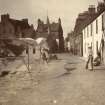
Architecture Notes

Stonehaven.

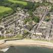
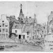
The National Trust Survey (1938) comments that despite recent demolition in the town, Stonehaven still retains a charming character. One group of houses in the High Street, 49-51, are of particular interest.

Classification: 2A. 4B. 12C. houses.

EXTERNAL REFERENCE:

National Trust for Scotland:

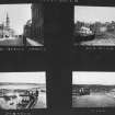
Photographs - Old Pier Tolbooth, 1-3, 2-8 & 7-9 Castle Street. 77-81 High Street & 1-2 Shorehead, 49-51, 43-47, 41, 35-39 High Street. 49-51 High Street. Threadneedle Street, Old Steeple and Cross.

List no.s 3, 4, 5, 6, 8, 11, 15, 10.

EXTERNAL REFERENCE

Scottish Field May 1953. Article and text. NMRS library has not got this issue.

Activities

Note (1984)

NO88NE 52 8729 8600

See also NO88NE 56.00.

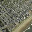
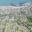
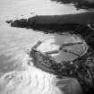
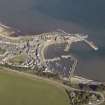
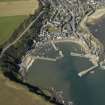
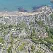
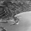
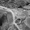
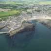
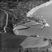
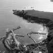
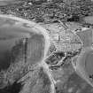
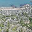
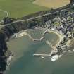
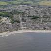
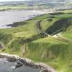
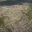
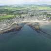
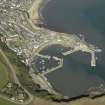
Stonehaven was erected a burgh of barony in 1587 and superseded Kincardine as the county town of Kincardineshire in the early 17th century. The town first developed to the S of the Carron Water, the area now known as Old Stonehaven, where there are the harbour (NO88NE 56), the 16th century tolbooth (NO88NE 20) and the market cross (NO88NE 4). In the later 18th century the area known as New Stonehaven was laid out to the N of the Carron Water; the clock tower (NO88NE 68) dates from this period.

G S Pryde 1965; R Gourlay and A Turner 1978; RCAHMS 1984.

References

MyCanmore Image Contributions


Contribute an Image

MyCanmore Text Contributions