
Following the launch of trove.scot in February 2025 we are now planning the retiral of some of our webservices. Canmore will be switched off on 24th June 2025. Information about the closure can be found on the HES website: Retiral of HES web services | Historic Environment Scotland
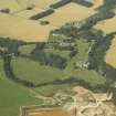
Ury House


Country House (19th Century), Estate (19th Century), House (Early 17th Century)
Site Name Ury House
Classification Country House (19th Century), Estate (19th Century), House (Early 17th Century)
Alternative Name(s) Old House Of Ury; Urie; Ury House Estate; Ury House Policies
Canmore ID 36912
Site Number NO88NE 32
NGR NO 85944 87721
Datum OSGB36 - NGR
Permalink http://canmore.org.uk/site/36912


- Council Aberdeenshire
- Parish Fetteresso
- Former Region Grampian
- Former District Kincardine And Deeside
- Former County Kincardineshire
NO88NE 32.00 85944 87721
NO88NE 32.01 85579 88950 Houff of Ury (Mausoleum)
NO88NE 32.02 85592 88922 Houff of Ury, Enclosing Walls
NO88NE 32.03 87013 88916 North Lodge
NO88NE 32.04 86418 86784 South Lodge
NO88NE 32.05 85323 87538 Blue Lodge
NO88NE 32.06 85800 88265 Ury Home Farm (and Sawmill)
NO88NE 32.07 85624 88242 Keeper's Cottage
NO88NE 32.08 85749 87897 Walled Garden
NO88NE 32.09 87140 87389 New Mains of Ury
NO88NE 32.10 87059 87289 New Mains of Ury Cottages
NO88NE 32.11 85956 87738 Terrace Walls
NO88NE 32.12 85819 87932 Coach House (Baille Na Choile)
NO88NE 32.13 85322 87523 Blue Lodge, Gate
NO88NE 32.14 86021 87767 Bridge over Ury Burn
NO88NE 32.15 85994 87803 Ice-house
NO88NE 32.16 85540 87800 Viaduct over Cowie Water
NO88NE 32.17 86425 86768 New Lodge, Boundary Walls and Gate-piers
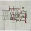
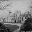
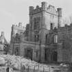
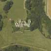
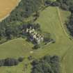
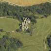
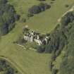
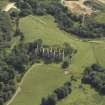
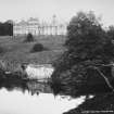
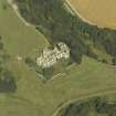
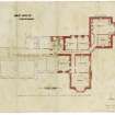
Ury House.
ARCHITECT: John Baird (Primus) - for Baird Family 1855, extensive additions later - gutted (Wing added 1884)
Alexander Ross 1882 - additions.
DEMOLISHED 1956
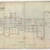
NMRS PLANS: F.A.M.MacDonald Collection
For plantation bank within Ury House policies (at NO 8641 8690), see NO88NE 45.
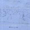
In 1854 the early 17th-century house of Ury was demolished to make way for the present mansion, now in a dilapidated condition. It was an L-plan house of three storeys, subsequently converted to the Z-plan by the addition of round towers at two of the diagonally opposite angles, and it is said to have been vaulted throughout.
Statistical Account (OSA) 1794; New Statistical Account (NSA) 1845; A Jervise 1861; W Macfarlane 1906-8; E H M Cox 1935; RCAHMS 1984, visited December 1983.
Listed.
Scottish Castle Survey 1988; N Bogdan and I B D Bryce 1991.
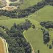
Visible on air photograph AAS/93/06/G14/15. Copy held by Grampian Regional Council.
Information from M Greig, Grampian Regional Council, March 1994.
Country house by John Baird ("no 1") of Glasgow, 1855, wing added 1884 by an unidentified architect. Now (1990) a roofless shell, the roof having been removed in post-war period. Ashlar, with sculptured detailing. ORIGINAL HOUSE: in revived English Tudor/Jacobean style, with off-centre tall square entrance tower with porch-cochere; otherwise 2/3 storeys; variety of window openings, mostly hood-moulded, often mullioned some canted/oriel windows, enormous mullioned and transomed window right hand of tower may have lit large hall; gabled dormer heads reach above eaves, bays set forward from main wall-planes are also gabled; engaged angle shafts, parapets, stacks. Double-gabled, return elevation to right is almost villa-like.WING: is on left-hand side of main front where front wall is breached; one pair gables crow-stepped; front wall. Buttressed, stepped, channeled and rock-faced terrace wall. (Historic Scotland)
Field Visit (December 1983)
NO88NE 32 859 877
In 1854 the early 17th-century house of Ury was demolished to make way for the present mansion, now in a dilapidated condition. It was an L-plan house of three storeys, subsequently converted to the Z-plan by the addition of round towers at two of the diagonally opposite angles, and it is said to have been vaulted throughout.
RCAHMS 1984, visited December 1983.
(Statistical Account (OSA) 1794; New Statistical Account (NSA) 1845; A Jervise 1861; W Macfarlane 1906-8; E H M Cox 1935)
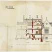
Standing Building Recording (10 October 2014 - 20 June 2016)
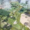
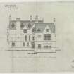
A Level 2 standing building survey was carried out between October 2014 and June 2016 during the soft strip of Ury House. Architects plans and elevations were annotated and a photographic survey carried out of internal and external walls and features. No access to the upper floors was possible during the first visits but when replacement floors were added and most areas became accessible and were recorded. Ury House is a country house built by John Baird of Glasgow in 1855 to replace an older house and a sketch exists of this earlier house. Baird closely modelled the plans for Ury on Burn's Carstairs with its big square entrance tower and porte cochere and mullioned and transomed windows. A wing was added 1884 by an unidentified architect and the building was abandoned after 1945 and was roofless at the first stages of the survey; new floors and roof were added part way through the survey. It is constructed from sandstone ashlar, a 'grotesquely affluent Tudor mansion'. Two phases of development of the main house were identified with several smaller modifications. The walled garden and ice-house, which are due to be redeveloped during a later phase, still require completion of the Level 2 Standing Building Survey.
Information from OASIS ID: camerona1-315068 (A Cameron) 2016
Archaeological Evaluation (3 September 2021 - 17 September 2021)
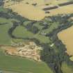
NO 87076 87561 GUARD Archaeology conducted an archaeological evaluation part of the required archaeological mitigation work at Ury Estate, Stonehaven, Section 7 road, Aberdeenshire. The archaeological evaluation revealed no new or previously unknown archaeological finds, features or deposits. The fieldwork was undertaken between the 3th and 17th of September 2021.
Much of the site is currently used as both pastoral and arable farmland and it is likely to have been used for agriculture for some time, although very little in the way of improvements were revealed by the evaluation besides a few possible field drains and furrows.
Information from OASIS Id: guardarc1-433897 (E. Perez-Fernandez) 2022
Photographic Survey
NO 85938 87720 (centred) A watching brief and photographic survey was carried out at Ury house, Stonehaven, prior to the construction of the improved access route. The remains of a demolished part of an existing wall were recorded during the watching brief. The fieldwork was undertaken between 24 and 25 June 2021.
Archive: NRHE (intended)
Funder: Private individual
Katharine Warden – GUARD Archaeology Ltd
(Source: DES Vol 22)

