
Drumtroddan 7


Cup And Ring Marked Rock (Neolithic) - (Bronze Age)
Site Name Drumtroddan 7
Classification Cup And Ring Marked Rock (Neolithic) - (Bronze Age)
Canmore ID 368494
Site Number NX34SE 148
NGR NX 36188 44700
Datum OSGB36 - NGR
Permalink http://canmore.org.uk/site/368494


- Council Dumfries And Galloway
- Parish Mochrum
- Former Region Dumfries And Galloway
- Former District Wigtown
- Former County Wigtownshire
Note (29 April 2019)
Date Fieldwork Started: 29/04/2019
Compiled by: ScRAP Team
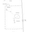
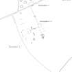
Location Notes: Drumtroddan 7 is part of a group of cup-and-ring marked rocks (Drumtroddan 5 - 7) located within an enclosure within a wooded area approximately 250m S of Drumtroddan Farm. Further rock art panels are located within two fenced-off enclosures approximately 70m to the E (Drumtroddan 1-4 and Drumtroddan 8-13). Drumtroddan 5 - 7 are part of the same Canmore ID (62767) and HER record (MDG2439). Together with the panels within the fenced-off enclosures they are part of the same scheduled monument designation (SM90101), and are properties in care. Drumtroddan standing stones (Canmore ID: 62762) are approximately 400m to the S.
Drumtroddan 7 is located close to the SW corner of the enclosure about 5m to the W of Drumtroddan 5, the largest panel in the enclosure. Drumtroddan 6 is located about 1m to the S of Drumtroddan 5. The enclosure within the wooded area is separated from the field by a drystone field dyke with a stone stile set into it. The enclosure measures approximately 10x12m.
The panels all lie at the highest point of the field, and there are views in particular to the N towards Drumtroddan farm, and beyond to the N and NE towards the Galloway hills. Views in other directions are partially obscured by trees.
Panel Notes: Drumtroddan 7 is an exposure of slightly pinkish greywacke outcropping measuring 1.1 x 0.7m and rising to 0.1m at its highest. It slopes towards the NW. The panel is located under a tree and was heavily moss covered. Near the upper end of the panel there is a single cup and one ring, with a short radial extending from the outer edge of the ring towards the SW. Further down the slope of the panel there is a long groove in an arc shape with a smaller arc within its curve. The panel is heavily eroded and friable in parts, particularly on its E side.

