
Drumtroddan 13


Cup And Ring Marked Rock (Neolithic) - (Bronze Age)
Site Name Drumtroddan 13
Classification Cup And Ring Marked Rock (Neolithic) - (Bronze Age)
Canmore ID 368489
Site Number NX34SE 143
NGR NX 36265 44731
Datum OSGB36 - NGR
Permalink http://canmore.org.uk/site/368489


- Council Dumfries And Galloway
- Parish Mochrum
- Former Region Dumfries And Galloway
- Former District Wigtown
- Former County Wigtownshire
Note (2 May 2019)
Date Fieldwork Started: 02/05/2019
Compiled by: ScRAP Team
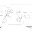
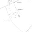
Location Notes: Drumtroddan 13 is part of a group of cup-and-ring marked rocks (Drumtroddan 8 - 13) located within a fenced-off area in a field approximately 200m S of Drumtroddan Farm. Further rock art panels are located within a similarly fenced-off enclosure approximately 20m to the SE (Drumtroddan 1 – 4), and within a wooded area approximately 70m to the W (Drumtroddan 5 – 7). Drumtroddan 8-13 are part of the same Canmore ID (62751) and HER record (MDG2423) and, together with the panels in the other fenced-off enclosure and within the wooded area, are included within the same scheduled monument designation (SM90101), and are properties in care.
The two enclosures within the field are part of a large area of outcropping rock. There are views in all directions, and particularly to the N, E and W, with the Galloway hills visible in the distance to the NE. Drumtroddan standing stones (Canmore ID: 62762) are approximately 400m to the S. The enclosure within which Drumtroddan 13 is located, measures approximately 8m x 16m. All the panels within this group are found on a single area of exposed outcrop ridge running broadly NW-SE certain parts of which are turf-covered.
Drumtroddan 13 is located at the W end of the grouping close to the fenced boundary. Drumtroddan 12 lies approximately 2.2m to its E, with Drumtroddan 11 a further 0.9m to the E.
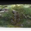
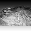
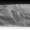
Panel Notes: Drumtroddan 13 is a gently sloping panel measuring 1.8 x 1.6m and rising to 0.8m at its highest. The panel slopes broadly towards the N and is partially turf-covered in its middle section, running into the turf at its N (lower) end. At its S (upper) end the panel edge is more clearly definited and on its W side it drops vertically towards the ground. The panel contains a number of motifs, many of which are quite eroded and hard to discern.
At the N edge, separated from the rest of the panel by turf, there is a small area of exposes rock with a cup-and-ring motif, flanked by two possible cupmarks and with two gutters extending from the ring.

