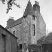
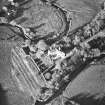
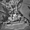
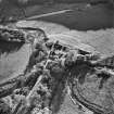
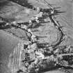
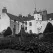
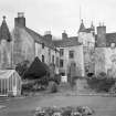
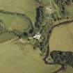
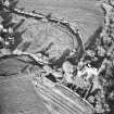
Accessibility

Font Size

100% 150% 200%

Background Colour

Default Contrast
Close Reset

Allardice Castle

Tower House (Medieval)

Site Name Allardice Castle

Classification Tower House (Medieval)

Alternative Name(s) Castle Of Allardice; Allardyce Castle

Canmore ID 36839

Site Number NO87SW 12

NGR NO 81736 73947

Datum OSGB36 - NGR

Permalink http://canmore.org.uk/site/36839

Ordnance Survey licence number AC0000807262. All rights reserved.
Canmore Disclaimer. © Bluesky International Limited 2025. Public Sector Viewing Terms

Toggle Aerial | View on large map

Digital Images

Allardice Castle. View of South-West corner tower of South-West wing.
Allardice Castle. View of South-West corner tower of South-West wing.Oblique aerial view centred on the tower-house, taken from the NW.Oblique aerial view centred on the tower-house, taken from the S.Allardice Castle, NO87SW 12, Ordnance Survey index card, page number 1, RectoAllardice Castle. General view from South.Oblique aerial view centred on the tower-house, taken from the SSE.Oblique aerial view centred on the tower-house, taken from the SE.Allardice Castle. General view from North-East.Oblique aerial view centred on the tower-house, taken from the WSW.Allardice Castle. View of South-East wing from South.General view.Oblique aerial view centred on the tower-house, taken from the NNE.Oblique aerial view centred on the tower-house, taken from the SE.Allardice Castle, NO87SW 12, Ordnance Survey index card, RectoGeneral view.Allardice Castle. General view from South.Allardice Castle. General view from North-East.View of entrance.General view.Allardice Castle. View of South-East wing from South.Allardice Castle. View of South-West wing from South-East.View of corbelled stair-well.Oblique aerial view centred on the tower-house, taken from the S.Oblique aerial view centred on the tower-house, taken from the N.View of South-East wing from South-West.Allardice Castle, NO87SW 12, Ordnance Survey index card, page number 2, VersoView of South-East wing from South-West.Allardice Castle. View of South-West wing from South-East.Oblique aerial view centred on the tower-house, taken from the SW.Oblique aerial view centred on the tower-house, taken from the SSW.Allardice Castle. View of South-West corner tower of South-West wing.General view.

Administrative Areas

  • Council Aberdeenshire
  • Parish Arbuthnott
  • Former Region Grampian
  • Former District Kincardine And Deeside
  • Former County Kincardineshire

Archaeology Notes

NO87SW 12.00 81736 73947

NO87SW 12.01 c. 81729 73932 Gatepiers

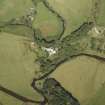
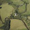
(NO 8173 7394) Castle of Allardice (NAT)

OS 1:10000 map (1973)

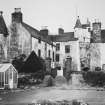
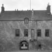
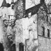
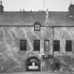
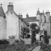
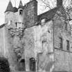
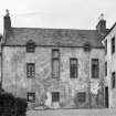
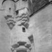
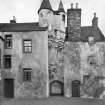
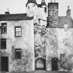
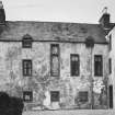
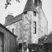
Allardyce Castle, probably built at the beginning of the 17th century, but so much altered that the original plan is no longer recognisable. The building is remarkable only for the extraordinary development of label moulding in the corbelling.

D MacGibbon and T Ross 1887

Castle of Allardice, as described, is still occupied.

Visited by OS (NKB) 14 December 1967

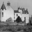
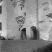
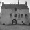
Allardyce Castle, a mansion, probably of late 16th century date, is now occupied as a farmhouse. Although giving the impression of belonging all to one period, the two wings of its original L-plan have been extended, that to the W very considerably, about a century later. The building has formed two sides of a courtyard, the remainder of which has been enclosed by a curtain-wall, and access thereto gained by a pend through the basement of the main block. In the main the walls rise to four storeys and an attic, and are roughcast and whitewashed. The basement is vaulted. A stone built into part of the extension is dated 1695.

N Tranter 1966

Listed.

Scottish Castle Survey 1988; N Bogdan and I B D Bryce 1991.

Architecture Notes

NMRS NOTES

Allardice Castle.

17th century. Very fine corbelling. Fairly small.

EXTERNAL REFERENCE

National Library

Glasgow Architectural Association Sketch Book, vol ii, 1887.

Edinburgh Architectural Association Sketch Book, 1875-6- general view.

References

MyCanmore Image Contributions


Contribute an Image

MyCanmore Text Contributions