
Pricing Change
New pricing for orders of material from this site will come into place shortly. Charges for supply of digital images, digitisation on demand, prints and licensing will be altered.
Upcoming Maintenance
Please be advised that this website will undergo scheduled maintenance on the following dates:
Thursday, 9 January: 11:00 AM - 3:00 PM
Thursday, 23 January: 11:00 AM - 3:00 PM
Thursday, 30 January: 11:00 AM - 3:00 PM
During these times, some functionality such as image purchasing may be temporarily unavailable. We apologise for any inconvenience this may cause.
Warren Field


Pit(S) (Period Unassigned), Pit Alignment (Prehistoric)
Site Name Warren Field
Classification Pit(S) (Period Unassigned), Pit Alignment (Prehistoric)
Alternative Name(s) Crathes Castle
Canmore ID 36671
Site Number NO79NW 18
NGR NO 7375 9668
Datum OSGB36 - NGR
Permalink http://canmore.org.uk/site/36671


- Council Aberdeenshire
- Parish Banchory-ternan
- Former Region Grampian
- Former District Kincardine And Deeside
- Former County Kincardineshire
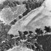
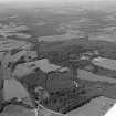
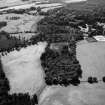
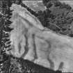
NO79NW 18 737 966.
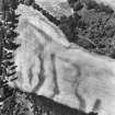
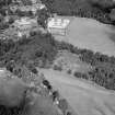
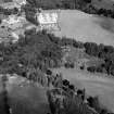
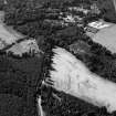
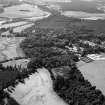
Cropmarks reveal an irregular line of pits extending for at least 80m from NE to SW across a field about 350m ESE of Crathes Castle. Other possible pits are scattered across the area between the pit-alignment and the timber building (NO79NW 17), 160m to the E.
RCAHMS 1984.
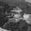
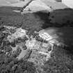
NO 739 967 (building); NO 737 966 (pit alignment) The site was first recognised in 1976 as a series of cropmarks revealed by aerial photography. In 2004, a two-week assessment excavation (DES 2004, 11) demonstrated that these cropmarks represented a well-preserved Early Neolithic building (NO79NW 17) and a contemporary pit alignment (NO79NW 18), both yielding radiocarbon dates in the range c 3800-3700 BC. A more intensive season of excavation was undertaken in May and June 2005, with three main aims: to reveal the full plan of the building and investigate
its structure; to fully examine the pit alignment; and to investigate cropmarks in the area between the building and the alignment.
The Warren Field building was c 24 x 9m externally and 22.5 x 8m internally. However, there is a possibility that the W segment of the structure, which was less substantial, may have been an unroofed area or may have been dismantled during the life of the building, with the roofed part of the building being c 18.5 x 8m internally. The interior was further sub-divided by a series of partitions. The main entrance was to the NE, with two narrow gaps between the timbers in the side walls possibly providing light and air to the inner rooms.
The outer walls were built of large oak timbers set vertically in segmented foundation trenches. The bases of the timbers had been charred before construction and, as the building had been subsequently destroyed by fire, the burnt post-pipes were in most cases very clear so it was possible to see that both round and split timbers had been used. The internal partitions had been constructed of lighter timbers and there is clear evidence that some of them had been replaced or augmented by new timbers set alongside. Two large pits lay on the longitudinal axis of the building: their function is unclear but they do not appear to have held roof supports.
Preliminary analysis of the finds distribution indicates that there was little activity in the possibly open area at the extreme W end. Within the main area of the structure there was a concentration of flint artefacts to the W, with a lower concentration at the E end, and very few flints in the central area. The distribution of pottery was in
reverse, with little to the W and an increasing concentration towards the centre and E of the structure. Superficially this may suggest functional differences between the different areas of the structure although it must be stressed that, as no floor levels survived, this is based solely on finds from the fills of negative features.
Systematic environmental sampling was undertaken throughout the building and analysis may show if there is any pattern in the distribution of grain. In 2004, barley (dominant), emmer, bread/club wheat, and a possible grain of spelt were identified from the E end of the building. Bone only survived as small burnt fragments, most of which are likely to be too small for species identification. It is hoped that lipid analysis of some of the pottery may give an indication of bovine milk fats and, by inference, the exploitation of domesticated cattle.
Excavation of the nearby pit alignment indicated that it was a far more complex monument than it had initially appeared. In 2004, one pit in the alignment was sectioned and a further six pits and five smaller features were planned. In 2005, a further five pits were revealed and sectioned. Consistently, all the pits had a sequence of an initial cut with some slippage from the sides, then a thick deposit of charcoal followed by infilling from weathering of the edges and
possibly erosion and slippage of the upcast material. In each pit this process was then interrupted by a secondary cut, with a fill which again included large amounts of charcoal. It is hoped that the function and sequence of these pits may be clarified by the analysis of charcoal, pollen, soil chemistry and soil micromorphology which is in progress. A single radiocarbon date from the pit sectioned in 2004 suggests that the timber in the pit fill was contemporary with the Neolithic building. In 2005 a sequence of samples has been taken to test this and to attempt to see if the pits were broadly contemporary or sequential.
Two trial excavations of small cropmarks in the area between the pit alignment and the hall were disappointing as they proved to be a 19th-century pit and an area of natural silting. This, however, stresses the continued agricultural use of the ground and does not rule out the possibility that some of the other cropmarks may be of prehistoric origin.
Report to be lodged with Aberdeenshire SMR and NMRS.
Sponsors: HS A , NTS, Aberdeenshire Council, Society of
Antiquaries, Prehistoric Society, Russell Trust.
NO 737 966 Aerial photography of the site in 1976 had revealed cropmarks of a rectangular building, a nearby pit alignment and a number of smaller features. Following an initial evaluation excavation of the site in 2004 (DES 2004, 11), the Neolithic timber hall was fully excavated in May 2005 and five pits of the pit alignment were sectioned (DES 2005, 12-13). All of the sectioned pits in the alignment proved to have had an initial cut partially filled by erosion and slippage of upcast material. Subsequently each of the pits had been recut. Radiocarbon dates from samples taken in 2005 of the primary fills of four pits were of Mesolithic date but dates from the recuts of two pits were of Neolithic date.
This implied that the line of pits had been dug in the Mesolithic and had still been visible in the landscape and partially recut in the Neolithic. To test this, a further two pits were sectioned in 2006 and a further 10 samples dated. In total there are now 11 dates from primary fills of six pits with a date range of between 8850+40 BP (SUERC 12266: 8210-7790 Cal. BC) and 7945+40 BP (SUERC 12256 : 7040-6690 Cal.BC). All these Mesolithic dates are from short-lived species such as hazel, alder, willow and birch and one from a hazelnut. There were only suitable samples for four dates from the final recut of two pits. These gave a date range between 5200+35BP (SUERC 12251: 4160-3950 Cal. BC) and 4975+45 BP (SUERC 10074: 3940-3650 Cal. BC). The oldest dates in this Neolithic sequence are from oak and may therefore be artificially old, but the youngest date is from grain.
One of the pits sectioned in 2006 was the largest in the group and the only one to yield finds. Graeme Warren (University College, Dublin) reports that four flints were identified in association with Mesolithic radiocarbon dates within the pit. These are regular flakes and blades that would be in keeping with either a Mesolithic or early Neolithic date. A total of 26 artefacts of a distinctive, but difficult to identify, raw material were recovered from the uppermost fills of the same pit. Geological analysis is ongoing, but the objects include two definite polished axe fragments and a range of chunks and flakes.
The Neolithic dates from the final recuts closely match the dates from the timber hall. This may suggest that, whatever the intention, the pits of the pit alignment were recut by people using the hall. The range of the Mesolithic dates appears to suggest that the pits may originally have been dug at intervals over a period of time, not as a single act, although this does not necessarily mean that they were not regarded as part of a sequence of events that created a single monument.
Continuing work undertaken in 2005, a number of smaller features visible on the 1976 aerial photographs in the area between the hall and the pit alignment were also excavated. Several were clearly modern but a small pit containing grain appears to have been of Iron Age or medieval date. A line of stone packed post-pits could not be dated but did not appear modern. The lack of even stray finds in any of these peripheral areas gives an impression that the Neolithic hall was not directly surrounded by any concentration of contemporary settlement.
Archive to be deposited with NTS and NMRS.
Sponsors: NTS, HS, Aberdeenshire Council, the Mackay and Brewer Charitable Trust, Robert B Jeffrey Fund, Mrs JY Nelson Charitable Trust, Miss Ross, the PF Charitable Trust, Society of Antiquaries of London.
HK Murray and JC Murray, 2006.
Project (1 June 1976 - 31 August 1976)
On the recommendation of the Committee for Rescue Archaeology set up by the Scottish Ancient Monuments Board a grant was made to the Commission in 1976 to allow it to carry out an extensive aerial survey programme. Climatic conditions during the period June-August were exceptionally favourable in much of eastern Scotland and more than 600 monuments were recorded, the majority being identified by means of crop-markings, a large number of which were new discoveries. The most interesting sites included Dark Age or Medieval timber halls on Deeside (NO 737967 [NO79NW 18], 733959 [NO79NW 16]) and west of Brechin (NO 509585 [NO55NW 40]); new Roman temporary camps at Ford, Midlothian (NT 384638 [NT36SE 18]) and Millside Wood [sic], Roxburghshire (NT 690270); double pit-alignments at Kinnell and Kinalty, Angus (NO 605494 [NO64NW 27], 356512 [NO35SE 32]); and a number of small, square-ditched enclosures, possibly barrows of the later Iron Age, in the Lunan valley, Angus (NO 626491 [NO64NW 95], 618494 [NO64NW 41] and 687509 [NO65SE 18]). A summary list of all these sites has been compiled and the prints will shortly be available for inspection in the National Monuments Record of Scotland.
RCAHMS (DES 1976, 84)
Aerial Photographic Transcription (29 November 1995)
An aerial transcription was produced from oblique aerial photographs. Information from Historic Environment Scotland (BM) 31 March 2017.
Field Visit (June 1997 - June 1997)
This crop mark has been identified through aerial reconnaissance carried out by the RCAHMS in 1976. Photographs show an irregular line of pits stretching for 90 m, orientated north-east to south-west, situated about 350 m east south-east of Crathes Castle. Other possible pits have been recorded in the open ground between this site and the putative timber hall (NO79NW 16, Monument 34) located 150 m to the east (CRT97 037).
Information from NTS (BNMMB) November 2014
Watching Brief (12 August 2008 - 13 August 2008)
NO 7380 9654 A watching brief was carried out, 12–13 August 2008, during the mechanical excavation of 130 tree planting holes to within c300–400m of the Warren Field timber hall (NO79NW 17) and pit alignment (NO79NW 18). Two stone features might be related to 19th-century dykes. An isolated sherd of Early Neolithic pottery emphasised the potential of finding further prehistoric activity in this part of the estate.
Report: Aberdeenshire SMR, NTS and RCAHMS
Funder: The National Trust for Scotland
HK and JC Murray (Murray Archaeological Services Ltd), 2008

