
Pricing Change
New pricing for orders of material from this site will come into place shortly. Charges for supply of digital images, digitisation on demand, prints and licensing will be altered.
Upper Balfour


Ring Cairn (Neolithic) - (Bronze Age)
Site Name Upper Balfour
Classification Ring Cairn (Neolithic) - (Bronze Age)
Canmore ID 36646
Site Number NO79NE 30
NGR NO 7827 9597
Datum OSGB36 - NGR
Permalink http://canmore.org.uk/site/36646


- Council Aberdeenshire
- Parish Durris
- Former Region Grampian
- Former District Kincardine And Deeside
- Former County Kincardineshire
Field Visit (March 1984)
NO79NE 30 7827 9597.
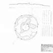
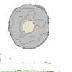
This severely robbed ring-cairn is situated 590m SW of Upper Balfour farmhouse within a field-system and cairnfield (NO79NE 28). It measures 18m in diameter over all by a maximum of 0.5m in height, but in some places the cairn material has been almost totally removed. At least twelve outer and seven inner kerbstones are visible, and the interior measures about 3m in diameter. Immediately outside the line of the inner kerb on the NW, there are two slabs set in a line running from NE to SW 0.6m apart.
RCAMS 1984, visited March 1984.
Measured Survey (6 March 1984)
RCAHMS undertook a 1:2500 plan of the cairns, hut circle and field system at Upper Balfour in 1983. The field survey drawing was redrawn in ink.
Field Visit (11 May 2005)
Situated in an area of unimproved ground, now overgrown with gorse and whin, this ring-cairn lies within a field-system of stony banks and small cairns. It has been heavily robbed and its internal court, which measures about 5.5m in diameter, is partly infilled with rubble. Overall the cairn measures 20m from N to S by 18m transversely and no more than 0.5m in height. Fifteen outer kerbstones are visible, most occurring singly, though six lie in pairs and three form a row on the WNW. Ten internal kerbstones define the central court, those on the S exposed at the edge of a robber trench. The majority of the kerbstones, both internally and externally, are of grey granite, and there is little evidence to suggest that they are graded in height.
Visited by RCAHMS (ARG) 11 May 2005
Measured Survey (11 May 2005)
RCAHMS surveyed Upper Balfour ring-cairn on 11 May 2005 with plane table and alidade producing a plan and section at a scale of 1:100. The survey drawing was later used as the basis for an illustration redrawn in vector graphics software at a scale of 1:250.

