
Burnhead Of Monboddo


Ring Ditch (Period Unassigned), Souterrain(S) (Prehistoric), Unenclosed Settlement (Period Unassigned)
Site Name Burnhead Of Monboddo
Classification Ring Ditch (Period Unassigned), Souterrain(S) (Prehistoric), Unenclosed Settlement (Period Unassigned)
Alternative Name(s) Burnhead Of Monboddo 2
Canmore ID 36475
Site Number NO77NW 44
NGR NO 749 793
Datum OSGB36 - NGR
Permalink http://canmore.org.uk/site/36475


- Council Aberdeenshire
- Parish Fordoun
- Former Region Grampian
- Former District Kincardine And Deeside
- Former County Kincardineshire
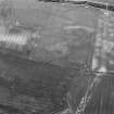
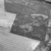
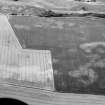
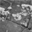
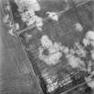
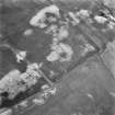
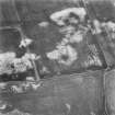
NO77NW 44 749 793.
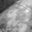
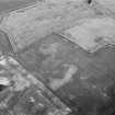
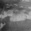
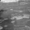
(Location cited as NO 749 793). Burnhead of Monboddo. Air photography (AAS/82/9/R3/10-13) has recorded several short curvilinear cropmarks and those of a possible rectilinear feature on a ridge at an altitude of 120m OD.
NMRS, MS/712/36.

