
Pricing Change
New pricing for orders of material from this site will come into place shortly. Charges for supply of digital images, digitisation on demand, prints and licensing will be altered.
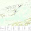
North Sutor, Coast Battery


Barracks(S) (Second World War)
Site Name North Sutor, Coast Battery
Classification Barracks(S) (Second World War)
Alternative Name(s) Cromarty Defences; Fort North Sutor, Site No. 1
Canmore ID 364229
Site Number NH86NW 22.04
NGR NH 81882 68978
NGR Description centred
Datum OSGB36 - NGR
Permalink http://canmore.org.uk/site/364229


- Council Highland
- Parish Nigg (Ross And Cromarty)
- Former Region Highland
- Former District Ross And Cromarty
- Former County Ross And Cromarty
Field Visit (15 March 2019)
These five buildings (NH 81938 68989, NH81909 68983, NH 81879 68975, NH 81851 68969, NH 81822 68960), which formed part of the camp introduced by the Army to sustain the battery during the Second World War, are situated within a shelterbelt immediately NNW of the track leading from the North Sutor Land Service Battery Site No.1 to Site No.2 (NH86NW 9.48). All are rectangular on plan and the four most easterly are laid out in end-to-end pairs about 6m apart. Each is provided with a washroom at one end – these abutting one another to rationalise the system of drainage, with inspection covers situated in the space between them. The buildings measure 23.5m from ENE to WSW by 4.8m transversely within a plinth made up of brick panels 0.24m thick and up to 0.5m high, interspersed with narrow slots rising above concrete blocks 0.45m square. This carried a timber superstructure, the wooden posts in the slots being underpinned by the blocks supporting the frame. The washrooms, which are confined to a short section at one end of the building, are floored with thick concrete underlain with a damp-proof course of thin bitumen between it and the top course of brickwork. The remains of ceramic waste pipes, urinal trays and sometimes a gutter moulded into the concrete floor indicate that each was equipped with two WCs, at least one shower and possibly both hand basins and urinals. Short lengths of paving leading from the track to thresholds indicate that the entrance to each building was centrally located on the SSW.
The fifth building (NH 81822 68960), set at a slight angle and only 4m apart from its nearest neighbour, is similar but slightly larger, as it measures 27m from ENE to WSW by 5.7m transversely.
These buildings are annotated ‘Men’s Sleeping Quarters’ (i.e. a barrack blocks) on an undated sketch map entitled ‘Layout of Fort North Sutor’ within the Fort Record Book held in The National Archives at Kew (WO192/248). It is also depicted on two RAF aerial photographs (106G/RAF/0751/6039-40) flown on 31 August 1945, which also clearly show the short paths leading from the track towards the central entrances.
Visited by HES, Survey and Recording (ATW, AKK), 15 March 2019.

