Accessibility

Font Size

100% 150% 200%

Background Colour

Default Contrast
Close Reset

Dubton

Pit(S) (Prehistoric), Rig And Furrow (Medieval) - (Post Medieval), Ring Ditch(S) (Prehistoric), Unenclosed Settlement (Prehistoric)

Site Name Dubton

Classification Pit(S) (Prehistoric), Rig And Furrow (Medieval) - (Post Medieval), Ring Ditch(S) (Prehistoric), Unenclosed Settlement (Prehistoric)

Canmore ID 36382

Site Number NO76SW 9

NGR NO 7050 6070

NGR Description Centred on NO 7050 6070

Datum OSGB36 - NGR

Permalink http://canmore.org.uk/site/36382

Ordnance Survey licence number AC0000807262. All rights reserved.
Canmore Disclaimer. © Bluesky International Limited 2025. Public Sector Viewing Terms

Toggle Aerial | View on large map

Digital Images

Oblique aerial view centred on the cropmarks of the unenclosed settlement, ring ditches, souterrain, pits and rig at Dryleys and Dubton, looking to the SE.
Oblique aerial view centred on the cropmarks of the unenclosed settlement, ring ditches, souterrain, pits and rig at Dryleys and Dubton, looking to the SE.Oblique aerial view centred on the cropmarks of the unenclosed settlement, ring ditches, pits, possible souterrain and rig at Dryleys and Dubton, looking to the NNW.Oblique aerial view centred on the cropmarks of the unenclosed settlement, ring ditches, pits, possible souterrain and rig at Dryleys and Dubton, looking to the NNE.Oblique aerial view centred on the cropmarks of the unenclosed settlement, ring ditches, souterrain, pits and rig at Dryleys and Dubton with Hillside adjacent, looking to the NNW.Dubton, NO76SW 9, Ordnance Survey index card, page number 1, RectoDubton, NO76SW 9, Ordnance Survey index card, RectoOblique aerial view of the cropmarks of the unenclosed settlement, buildings, and rig, looking SSE.Oblique aerial view centred on the cropmarks at Dryleys, looking WNW.Oblique aerial view centred on the cropmarks of the unenclosed settlement, ring ditches, souterrain, pits and rig at Dryleys and Dubton, looking to the SSE.

Administrative Areas

  • Council Angus
  • Parish Montrose
  • Former Region Tayside
  • Former District Angus
  • Former County Angus

Activities

Field Visit (April 1978)

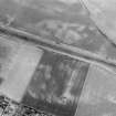
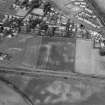
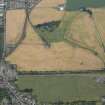
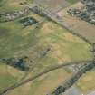
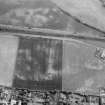
Dubton NO 704 607 to 706 607 NO76SW

The crop-marks of what is probably a small unenclosed settlement have been recorded on a gentle rise ENE of Dubton. A line of five circular marks, each measuring about 12m in diameter, probably represent the sites of houses; the perimeter of one appears to be delineated by pits. Nearby there are at least three smaller rings, which measure about 6m in diameter, and there may be two more houses about 100m further E.

RCAHMS 1978, visited April 1978

References

MyCanmore Image Contributions


Contribute an Image

MyCanmore Text Contributions