|
Photographs and Off-line Digital Images |
AN 5649 |
RCAHMS Aerial Photography |
Oblique aerial view. |
1982 |
Item Level |
|
|
Photographs and Off-line Digital Images |
AN 5646 |
RCAHMS Aerial Photography |
Oblique aerial view. |
1982 |
Item Level |
|
|
Photographs and Off-line Digital Images |
AN 5647 |
RCAHMS Aerial Photography |
Oblique aerial view. |
1982 |
Item Level |
|
|
Photographs and Off-line Digital Images |
AN 5648 |
RCAHMS Aerial Photography |
Oblique aerial view. |
1982 |
Item Level |
|
|
Photographs and Off-line Digital Images |
AN 5650 |
RCAHMS Aerial Photography |
Oblique aerial view. |
1982 |
Item Level |
|
|
Photographs and Off-line Digital Images |
AN 5651 |
RCAHMS Aerial Photography |
Oblique aerial view. |
1982 |
Item Level |
|
|
Photographs and Off-line Digital Images |
AN 5961 |
RCAHMS Aerial Photography |
Oblique aerial view. |
1982 |
Item Level |
|
|
Photographs and Off-line Digital Images |
B 16267 |
RCAHMS Aerial Photography |
Oblique aerial view. |
1988 |
Item Level |
|
|
Photographs and Off-line Digital Images |
B 16268 |
RCAHMS Aerial Photography |
Oblique aerial view. |
1988 |
Item Level |
|
|
Photographs and Off-line Digital Images |
C 27629 |
RCAHMS Aerial Photography |
Oblique aerial view. |
5/7/1994 |
Item Level |
|
|
Photographs and Off-line Digital Images |
C 27630 |
RCAHMS Aerial Photography |
Oblique aerial view. |
5/7/1994 |
Item Level |
|
|
Photographs and Off-line Digital Images |
C 27631 |
RCAHMS Aerial Photography |
Oblique aerial view. |
5/7/1994 |
Item Level |
|
|
Photographs and Off-line Digital Images |
C 27632 |
RCAHMS Aerial Photography |
Oblique aerial view. |
5/7/1994 |
Item Level |
|
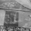 |
On-line Digital Images |
SC 1013260 |
Records of Aberdeen Aerial Surveys, Aberdeen, Scotland |
Oblique aerial view centred on the cropmarks of the unenclosed settlement, ring ditches, souterrain, pits and rig at Dryleys and Dubton, looking to the SSE. |
29/6/1982 |
Item Level |
|
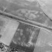 |
On-line Digital Images |
SC 1013262 |
Records of Aberdeen Aerial Surveys, Aberdeen, Scotland |
Oblique aerial view centred on the cropmarks of the unenclosed settlement, ring ditches, souterrain, pits and rig at Dryleys and Dubton, looking to the SE. |
29/6/1982 |
Item Level |
|
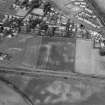 |
On-line Digital Images |
SC 1013263 |
Records of Aberdeen Aerial Surveys, Aberdeen, Scotland |
Oblique aerial view centred on the cropmarks of the unenclosed settlement, ring ditches, souterrain, pits and rig at Dryleys and Dubton with Hillside adjacent, looking to the NNW. |
29/6/1982 |
Item Level |
|
|
Photographs and Off-line Digital Images |
SC 1722692 |
RCAHMS Aerial Photography |
Oblique aerial view. |
1982 |
Item Level |
|
|
Photographs and Off-line Digital Images |
SC 1722693 |
RCAHMS Aerial Photography |
Oblique aerial view. |
1982 |
Item Level |
|
|
Photographs and Off-line Digital Images |
SC 1722694 |
RCAHMS Aerial Photography |
Oblique aerial view. |
1982 |
Item Level |
|
|
Photographs and Off-line Digital Images |
SC 1722695 |
RCAHMS Aerial Photography |
Oblique aerial view. |
1982 |
Item Level |
|
|
Photographs and Off-line Digital Images |
SC 1722696 |
RCAHMS Aerial Photography |
Oblique aerial view. |
1982 |
Item Level |
|
|
Photographs and Off-line Digital Images |
SC 1722697 |
RCAHMS Aerial Photography |
Oblique aerial view. |
1982 |
Item Level |
|
|
Photographs and Off-line Digital Images |
SC 1722704 |
RCAHMS Aerial Photography |
Oblique aerial view. |
1982 |
Item Level |
|
|
Photographs and Off-line Digital Images |
SC 1722710 |
RCAHMS Aerial Photography |
Oblique aerial view. |
1988 |
Item Level |
|


