
Pricing Change
New pricing for orders of material from this site will come into place shortly. Charges for supply of digital images, digitisation on demand, prints and licensing will be altered.
North Sutor, Coast Battery


Engine House (First World War)
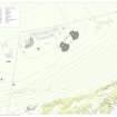
Site Name North Sutor, Coast Battery
Classification Engine House (First World War)
Alternative Name(s) Cromarty Defences; Fort North Sutor, Site No. 1
Canmore ID 363532
Site Number NH86NW 9.67
NGR NH 81806 68805
Datum OSGB36 - NGR
Permalink http://canmore.org.uk/site/363532


- Council Highland
- Parish Nigg (Ross And Cromarty)
- Former Region Highland
- Former District Ross And Cromarty
- Former County Ross And Cromarty
Field Visit (15 March 2019)
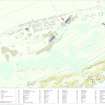
This building, which is terraced into a steep SSE-facing slope, formed part of the infrastructure of the battery introduced by the Admiralty during World War 2. It is rectangular on plan, and comprises three concentric moss- and grass-grown concrete platforms, with the outer incorporating an additional broad threshold on the S. The central platform is a plinth for a generator and retains two rows of three upright bolts in its upper surface. It measures 2.53m from E to W by 1.05m transversely and 0.01m high. The middle platform is damaged but measures 4.63m from E to W by 2.9m transversely and 0.1m high. A cable duct leads towards the plinth on the S and at least two nearby slots at its edge may have once held timber posts. In addition, its E end supports a light metal frame comprising two braced uprights and a crosspiece. The outer platform, with the threshold, measures 6.15m from E to W by at least 4.15m transversely. It seems that this Engine House, with its timber and light metal framework, once stood on a concrete plinth up to 1m wide.
The building is identified as a ‘Petrol Engine’ (i.e. an Engine House) on a sketch map entitled ‘Telephone Circuits’, dated 7 May 1919, held in the National Archives at Kew (ADM 7/942). This also shows that it originally lay within the W boundary of the WWI security fence (NH86NW 9.51) and possibly provided power to the Hydrophone Station (NH86NW 9.78) situated on the steep slope below some 80m SSE.
Visited by HES, Survey and Recording (ATW, AKK), 15 March 2019.

