
North Sutor, Coast Battery


Command Post (First World War)
Site Name North Sutor, Coast Battery
Classification Command Post (First World War)
Alternative Name(s) Cromarty Defences; Fort North Sutor, Site No. 1
Canmore ID 363525
Site Number NH86NW 9.59
NGR NH 81969 68949
Datum OSGB36 - NGR
Permalink http://canmore.org.uk/site/363525


- Council Highland
- Parish Nigg (Ross And Cromarty)
- Former Region Highland
- Former District Ross And Cromarty
- Former County Ross And Cromarty
Field Visit (13 March 2019)
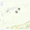
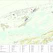
This building, which co-ordinated the fire of the World War 1 Admiralty Gun Emplacements No.1 and No.2, is situated midway between them. It is rectangular on plan and measures 2.26m from NE to SW by 1.7m transversely over reinforced cast concrete walls 0.16m thick. Although it is largely buried, it rises at least 1.4m above the present ground surface. It has a flat, overhanging concrete roof that still preserves fragments of a turf capping for camouflage; and beneath this there is a wide observation window facing SE, which is subdivided by a central metal support for the roof. There are three small circular sockets on the SW sector of the window’s sill, together with an iron bracket for the depression range finder which projects into the interior. Access is provided by a doorway on the NE, but much of the interior is now occupied by rubble. Nevertheless, it is evident that the walls were whitewashed, while wooden plugs for boards and battens on the SW and NW walls indicate the former presence of electrical equipment. Some of this must have been connected with the operation of the depression range finder, as the letters DRF are painted on the NW wall close by. In addition, the speaking tube that ran to Gun No.1 emerges from the SW wall, while that running to Gun No.2 emerges from the SE wall just below the observation window. Both would have run just below the surface of the ground originally, but a short section of that approaching Gun No.2 is now visible just beyond the post.
The building is identified as a ‘Gun Group Commander’ post on plans and sections held in the National Archives at Kew (WO78/5192: 16/19 and 4/19). These also indicate that the door led to a flight of steps that descended to an open-topped, underground passage that ran NW of the post in a straight line from NE to SW. This linked both of the guns, their magazines and their crew shelters. However, the passage is now also largely infilled with grass-grown rubble, although the outline of the section running towards Gun No.1 can still be traced for 8m SW. A sketch map of the battery entitled 'Telephone Circuits' (ADM7/942), dated 7 May 1919, also held at Kew, labels the building with the abbreviation 'GGC'.
Visited by HES, Survey and Recording (ATW, AKK), 13 March 2019.

