
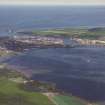
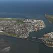
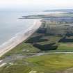
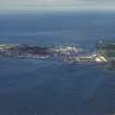
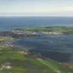
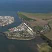
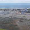
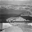
Montrose, General


Burgh (Medieval), General View (Period Unassigned), Town (Medieval) - (Post Medieval)
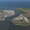
Site Name Montrose, General
Classification Burgh (Medieval), General View (Period Unassigned), Town (Medieval) - (Post Medieval)
Alternative Name(s) Stromnay; Sallork; Munros
Canmore ID 36246
Site Number NO75NW 33
NGR NO 7143 5772
NGR Description Centred NO 7143 5772
Datum OSGB36 - NGR
Permalink http://canmore.org.uk/site/36246


- Council Angus
- Parish Montrose
- Former Region Tayside
- Former District Angus
- Former County Angus
NO75NW 33
This site contains material which originally related to sites NO75NW 0.01 and NO75NW 0.02. Both of these sites have since been cancelled.
NMRS REFERENCE
Montrose, Tudor House (unlocated) Architect: W Orkney, 1901
Photographic Survey (1955)
Photographic survey of buildings in Montrose, Angus, by the Scottland National Buildings Record in 1955.
Note (1978)
Montrose
Montrose was a royal burgh by 1178, and the castle (NO 710 574), which was destroyed in the 19th century, and the church, which was removed to make way for the present parish church (NO 714 577), were probably in existence at or before that date.
RCAHMS 1978
(Stat Acct, v, 1793, 30, 32-3; Jervise 1861, 46-8; Warden 1880-85, iv, 430; Low 1891; Pryde 1965, 7-8, no. 15)
External Reference (1997)
(Possible predecessor settlement of Stromnay: also known as Sallork and Munros).
N K Atkinson 1997.

