Accessibility

Font Size

100% 150% 200%

Background Colour

Default Contrast
Close Reset

Easdale, Slate Waste Heap

Bing (19th Century) - (20th Century)

Site Name Easdale, Slate Waste Heap

Classification Bing (19th Century) - (20th Century)

Canmore ID 362038

Site Number NM71NW 149

NGR NM 73714 16979

Datum OSGB36 - NGR

Permalink http://canmore.org.uk/site/362038

Ordnance Survey licence number AC0000807262. All rights reserved.
Canmore Disclaimer. © Bluesky International Limited 2025. Public Sector Viewing Terms

Toggle Aerial | View on large map

Digital Images

Oblique aerial view of south shoreline from east showing the post-1899 slate waste tipping. This slate waste was probably generated by the re-opening of Windmill and Hill quarries in the early 20th century. The line of its tramway bed is visible on the right, its overbridge now gone. The quarry at the bottom of the image is overlain by the later sate waste tipping.
Oblique aerial view of south shoreline from east showing the post-1899 slate waste tipping. This slate waste was probably generated by the re-opening of Windmill and Hill quarries in the early 20th century. The line of its tramway bed is visible on the right, its overbridge now gone. The quarry at the bottom of the image is overlain by the later sate waste tipping. Oblique aerial view of slate waste tip or bing and the tramway that served it and part of the quarrying landscape.Oblique aerial view from south of An Lub Chlear Quarry, Klondyke Quarry and the slate waste heap/ tipping NM71NW 149 Oblique aerial view of slate waste bing on south side of Easdale and associated with post-1899 tramwayOblique aerial view of post-1899 tramway and slate waste tip or bing it was used to createOblique aerial view from west of south east part of islandOblique aerial view of south shoreline showing the post-1899 slate waste tipping. This slate waste was probably generated by the re-opening of Windmill and Hill quarries in the early 20th century. The line of its tramway bed is visible in the distance. The earlier Grieve's Cottage quarry is visible to the right of the waste tip in front of the white cottage.Oblique aerial view of south shoreline showing the post-1899 slate waste tipping. This slate waste was probably generated by the re-opening of Windmill and Hill quarries in the early 20th century. The line of its tramway bed is visible in the distance. The earlier Grieve's Cottage quarry is visible to the right of the waste tip in front of the white cottage.Oblique aerial view of tip or bing from west. Note erosion on its south flank.Oblique aerial view from west of area around waste tip/bing showing earlier quarrying in the area known as Camas Mor and the eastern edge of the south west spoil, walls and workingsOblique aerial view of post-1899 slate waste tip or bing from north westOblique aerial view from west showing slate waste bing on south side of the islandOblique aerial view from west with Fang and An Lub Chlear quarries nearest the camraOblique aerial view showing the general area which was known as the Camas Mor quarry area and slate waste heap NM71NW 149Oblique aerial view from west of area around waste tip/bing showing earlier quarrying in the area known as Camas Mor and the eastern edge of the south west spoil, walls and workingsOblique aerial view of south side of islandOblique aerial view showing slate waste bing associated with the post-1899 tramway.

Administrative Areas

  • Council Argyll And Bute
  • Parish Kilbrandon And Kilchattan
  • Former Region Strathclyde
  • Former District Argyll And Bute
  • Former County Argyll

Activities

Field Visit

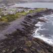
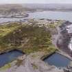
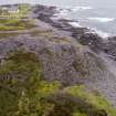
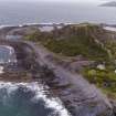
This slate waste heap is not depicted on the 2nd edition Ordnance Survey 25-inch map pf Easdale (Argyllshire, surveyed 1898, published 1899, sheet CCXXI.11). It exhibits much revetment on its steepest (south) side in order to ensure that it did not collapse during construction (slate waste is unstable when piled in heaps due to its lamination when broken up during quarrying activity).

The tramway which brought waste to the heap runs between the junction with the main Windmill Quarry/Hill Quarry and dates from after 1898, and was probably created after the re-opening of Hill Quarry c.1902.

NRS: GD/112/18/18, Report on the Easdale Slate Quarries, September 1902, (Breadalbane Papers).

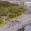
The bridge created over a former tramway bed running west/east along the south side of the island and which carried the tramway to access the dumping area is now lost (see DP264547). The substantial abutments of this bridge are in reasonably good condition.

Visited by Survey and Recording (MMcD), August 2017.

References

MyCanmore Image Contributions


Contribute an Image

MyCanmore Text Contributions