
Easdale


Tramway (19th Century)
Site Name Easdale
Classification Tramway (19th Century)
Canmore ID 362033
Site Number NM71NW 127.03
NGR NM 73708 17129
NGR Description linear
Datum OSGB36 - NGR
Permalink http://canmore.org.uk/site/362033


- Council Argyll And Bute
- Parish Kilbrandon And Kilchattan
- Former Region Strathclyde
- Former District Argyll And Bute
- Former County Argyll
Desk Based Assessment
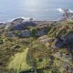
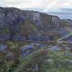
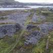
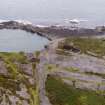
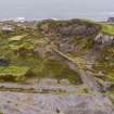
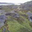
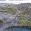
This tramway dates from after 1899 as it is not depicted on the 2nd edition Ordnance Survey 25-inch map (Argyllshire, 1899, sheet CXXI.11). It probably made its appearance after the re-opening of Hill Quarry c.1902. The spoil was tipped on a spoil heap on the south of the island (NM71NW 149). The tramway covers a considerable distance and overlies earlier quarrying and garden enclosures. A small bridge (now gone) was constructed over a former tramway at NM73735 17010 to carry the tramway onto the slate waste heap or tip on the south of the island.
The tramway is in a state of disrepair with some collapse of the embankment on which it stands. This is entirely built of slate waste.
National Records Scotland: GD 112/18/18, Report on the Easdale Slate Quarries, September 1902.
Information from M. McDonald, HES, Architecture and Industry, Survey and Recording Section, 19 June 2019.

