
Easdale


Tramway (19th Century)
Site Name Easdale
Classification Tramway (19th Century)
Canmore ID 362032
Site Number NM71NW 127.02
NGR NM 73534 17257
NGR Description centred; linear
Datum OSGB36 - NGR
Permalink http://canmore.org.uk/site/362032


- Council Argyll And Bute
- Parish Kilbrandon And Kilchattan
- Former Region Strathclyde
- Former District Argyll And Bute
- Former County Argyll
Publication Account
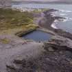
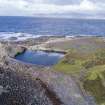
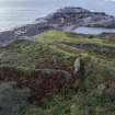
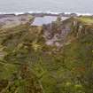
Bremner (1869) wrote an account of slate quarrying in the Easdale area and on Easdale Island. The first visitors to Easdale would have collected loose stones. Eventually a more controlled quarrying was undertaken using wooden wedges and water to split the slate exposed on the shore. This was followed by the opening of quarries near to the shore. Whole families were involved in slate removal, with creels on the backs of women used to move the slate to small boats/storage areas. A Newcomen engine was also installed but appeared to have been unprofitable. Horse operated pumps were introduced as a result around 'the beginning of this century' and presumably the use of carts and horses to remove more material than simply by barrowing and by carrying. 'About the year 1807' a windmill was erected to pump Windmill Quarry (NM71NW 114). In 1826 an engine was installed to pump 'three quarries'. Wharves were erected for loading ships. Railway inclines were then built in the quarries of a narrow gauge. Bremner notes that 'these were first worked by horses' but for a number of years they have been worked by steam.
D Bremner, 1869, Granite, Freestone, Pavement and Slate Quarrying section
Desk Based Assessment
This tramway does not appear on the 1st edition Ordnance Survey map (Argyllshire and Buteshire, 1871, Sheets CXX.7 and CXXI.11). It does appear on the 2nd edition Ordnance Survey 25-inch map (Argyllshire, surveyed 1898, published 1899, sheets CXXI.7 and CXXI.11) as it was built to serve the western quarries of An Toll mar Luaty, An Lub Chlear and Fang Quarry. It was also used after the abandonment of An Toll mar Luaty as there is substantial dumping of slate waste overlying the north east section of this quarry from, perhaps, the re-opening of Hill Quarry in the early 20th century. This slate waste material is visible on an RAF aerial photograph (NCAP_SCOT_106G_SCOT_UK_0049_4267) of 6 May 1946.
Information from Miriam McDonald, Survey and Recording Section, Heritage Directory, HES, 2019.

