
Easdale, Quarry Retaining Wall


Wall (Period Unassigned)
Site Name Easdale, Quarry Retaining Wall
Classification Wall (Period Unassigned)
Canmore ID 361467
Site Number NM71NW 118.03
NGR NM 73515 16984
NGR Description From NM73494 16873 to 75351 17000
Datum OSGB36 - NGR
Permalink http://canmore.org.uk/site/361467


- Council Argyll And Bute
- Parish Kilbrandon And Kilchattan
- Former Region Strathclyde
- Former District Argyll And Bute
- Former County Argyll
Field Visit (September 2015)
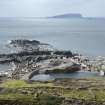
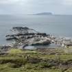
This quarry (NM71NW 118.00) has a concrete, shuttered, retaining wall running along its south west lip, measuring 0.3m in width. This wall continues on beyond the current edge of the quarry, heading west for approximately 4.5m and is in line with an area of waste tipping at NM73472 16968. This may be fortuitous, or the wall extension was used as a base of a tipping run from the quarry.
This quarry is depicted and named 'Quarry' on the 2nd edition of the Ordnance Survey 25-inch map (Argyllshire, revised 1898, published 1899, sheet CXXI.11). The 1st edition of the Ordnance Survey 25-inch map (Argyllshire and Buteshire, surveyed 1871 published 1872, sheet CXXI.11) does not show any quarrying at this location. A large group of garden enclosures are depicted immediately to the north west (centred NM7349117051) of the current quarry location. These are possibly under slate waste.
The tramway which served the quarry and depicted and named on the Ordnance Survey 2nd edition map, can seen as an embankment at NM73531 17001. It is part of the general reinforcement of the north east edge of the quarry to give a stable platform for the quarry buildings depicted (see NM71NW 118.02) on the OS 1899 map.
Visited by HES, Survey and Recording Section, 8/9 September 2015.

