
Easdale, Structure


Pit(S) (Period Unassigned)
Site Name Easdale, Structure
Classification Pit(S) (Period Unassigned)
Canmore ID 361450
Site Number NM71NW 118.01
NGR NM 73513 17028
Datum OSGB36 - NGR
Permalink http://canmore.org.uk/site/361450


- Council Argyll And Bute
- Parish Kilbrandon And Kilchattan
- Former Region Strathclyde
- Former District Argyll And Bute
- Former County Argyll
Note (1994)
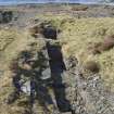
This structure consists of a long, narrow, slate-coursed, wall-lined pit with two cross walls. It measures approx. 6.0m in length by 1.6m in breadth and approx.1.0m in depth. The cross-walls measure 0.7m in thickness. Withall states that the structure's purpose is unknown.
See MS/8087/2
Desk Based Assessment (September 2015)
This structure is probably related to the large scale quarrying at NM71NW 118.00 after 1871 and before 1898 (2nd edition of the Ordnance Survey 25-inch map (Argyllshire, revised 1898, published 1899, sheet CXXI.10). This structure is not depicted on any of the Ordnance Survey maps and so may not have had a building above it. It is possibly associated with the remains of substantial quarry buildings to the south east (NM71NW 188.02).
The 1st edition of the Ordnance Survey 25-inch map (Argyllshire and Buteshire, surveyed 1871 published 1872, sheet CXXI.10) does not show any large scale quarrying in this area. A slope is depicted running south east below garden enclosures suggesting a change in ground level with the garden enclosures on a slightly higher, flat area. The garden enclosures in the immediate area of NM71NW 118.0 were either taken down or were buried by slate waste post-1871.
Information from HES, Survey and Recording Section, 8/9 September 2015.
Field Visit (September 2015)
This structure was observed during fieldwork in September 2016. This substantial structure survives to a depth of 1.0m, its south cross-wall has undergone more deterioration than the north cross-wall. It is undoubtedly the foundation for a piece of machinery, possibly a pump. It is probably not the foundation of a lifting crane or derrick. The pit is located behind a retaining support wall on the north east side of the quarry which has three apertures in it either to allow water seepage through the slate and mortar structure or to hold pipes for drainage pumps.
Visited by HES, Survey and Recording Section, 8/9th September 2015.

