
Following the launch of trove.scot in February 2025 we are now planning the retiral of some of our webservices. Canmore will be switched off on 24th June 2025. Information about the closure can be found on the HES website: Retiral of HES web services | Historic Environment Scotland
Langleypark


Field Boundary(S) (Post Medieval), Rig And Furrow (Medieval) - (Post Medieval)
Site Name Langleypark
Classification Field Boundary(S) (Post Medieval), Rig And Furrow (Medieval) - (Post Medieval)
Canmore ID 36014
Site Number NO66SE 19
NGR NO 6852 6018
NGR Description Centred at NO 6852 6018
Datum OSGB36 - NGR
Permalink http://canmore.org.uk/site/36014


- Council Angus
- Parish Dun
- Former Region Tayside
- Former District Angus
- Former County Angus
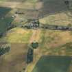
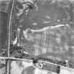
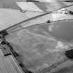
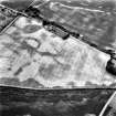
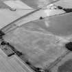
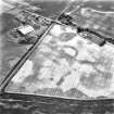
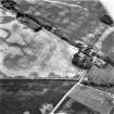
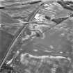
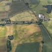
Several blocks of rig and furrow, field boundaries and drains have been recorded as cropmarks on oblique aerial photography (RCAHMS 1982, AAS 1998).
Information from RCAHMS (ACM) 29 April 2008
Field Visit (April 1978)
Langleypark 2 NO 68 60 NO66SE
A number of linear crop-markings have been recorded to the SE of Langleypark. The dominant mark appears to follow the old park boundary in a series of straight lines, running from NO 683 599 to NO 685 605, and it is likely that this and other linear marks, including an unconnected line at NO 687 599, are part of an earlier park layout.
RCAHMS 1978, visited April 1978

