
Pricing Change
New pricing for orders of material from this site will come into place shortly. Charges for supply of digital images, digitisation on demand, prints and licensing will be altered.
Upcoming Maintenance
Please be advised that this website will undergo scheduled maintenance on the following dates:
Thursday, 9 January: 11:00 AM - 3:00 PM
Thursday, 23 January: 11:00 AM - 3:00 PM
Thursday, 30 January: 11:00 AM - 3:00 PM
During these times, some functionality such as image purchasing may be temporarily unavailable. We apologise for any inconvenience this may cause.
North Berwick Law


Rig And Furrow (Post Medieval), Track(S) (Post Medieval)
Site Name North Berwick Law
Classification Rig And Furrow (Post Medieval), Track(S) (Post Medieval)
Alternative Name(s) Law Bank
Canmore ID 359707
Site Number NT58SE 148
NGR NT 5555 8383
Datum OSGB36 - NGR
Permalink http://canmore.org.uk/site/359707


- Council East Lothian
- Parish North Berwick
- Former Region Lothian
- Former District East Lothian
- Former County East Lothian
Field Visit (22 February 2018)
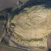
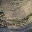
Remains of rig and furrow cultivation extend across a NNW-facing slope in a narrow field immediately to the south of the Law Quarry (NT58SE 136). The area measures about 410m from ENE to WSW by up to 100m transversely, but the surviving rigs undoubtedly represent only the remains of a once much larger area of such cultivation that would have originally extended into the arable fields immediately to the S. The individual rigs are orientated NNW and SSE, and measure up to 8m in breadth by 0.3m in height.
The field is annotated ‘Law Bank’ on an estate map of 1804 (NAS RHP 1726), when it belonged to a Law Side farm, the steading of which is depicted on the plan at NT 5536 8372. This steading, which comprised four buildings standing on the S side of a stack yard, was removed sometime in the first half of the 19th century and it is not depicted on the 1st edition of the OS 6-inch map (Haddingtonshire 1854, Sheet 2). The 1804 estate map also demonstrates that the straight field boundary on the south side of the rig was in place by that time, thus providing a terminus ante quem for the cultivation of the rigs. The boundary is shown accompanied (on its south side) by a row of trees which are smaller than some of the trees shown elsewhere on the plan, perhaps indicating that the field boundary was of comparatively recent build. The rigs are overlain by two footpaths at the E end; one of these is depicted on the 1st edition of the OS 6-inch map. More tracks can be seen running along the S part of the field from W to E.
Visited by HES Survey and Recording (GFG) 22 February 2018.
(NBL12)

