
Sanday, Whale Head Chain Home Radar Station


Radar Station (20th Century)
Site Name Sanday, Whale Head Chain Home Radar Station
Classification Radar Station (20th Century)
Alternative Name(s) Lopness
Canmore ID 3597
Site Number HY74SE 23
NGR HY 76138 43556
Datum OSGB36 - NGR
Permalink http://canmore.org.uk/site/3597


- Council Orkney Islands
- Parish Lady
- Former Region Orkney Islands Area
- Former District Orkney
- Former County Orkney
HY74SE 23.00 76138 43556
Orkney SMR Reference: OR 283, OR 3040
For remote reserve radar station see also HY74NE 9.00
HY74SE 23.01 HY 76282 44062 Engine house
HY74SE 23.02 centred HY 7537 4429 Military Camp
HY74SE 23.03 HY 7598 4410 Magazine
HY74SE 23.04 HY 76180 43721 Engine house (stand by)
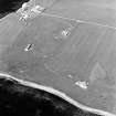
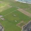
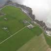
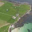
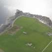
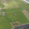
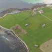
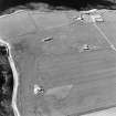
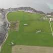
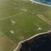
Extensive remains of one of the primary chain of air-defence radar stations.
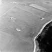
A large group of earthwork-protected concrete buildings and bunkers lies E of Lopness Farm. Other bunkers and dug-outs are widely spaced on both sides of the road running N through Lettan (area HY 758 452). The camp site was behind the dunes (in area HY 755 443) where Nissen Hut foundations are to be seen.
Visited by R G Lamb 1979
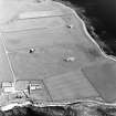
This Chain Home Radar station is situated to the E of Lopness farm. The transmitter and receiver blocks, main power station and the standby power station along with some of the mast bases survive. The main part of the radar station consisted of a transmitter block (Tx) (HY 7642 4355) with two 350 foot steel masts (HY 7643 4367), a receiver block (HY 7614 4356) with two 200 foot wooden masts with an additional single 90 foot mast. The main power station (HY74SE 23.01; HY 76282 44062) and a standby power station (HY 76180 43721). The site was defended by four Bofors Guns (HY 7599 4370, HY 7587 4398, HY 7695 4388 and HY 7630 4411) and minefields around the perimeter. The magazine is at HY 7598 4410 (HY74SE 23.03). The light AA guns were manned by the Kings Own Borderers. The radar station is visible on RAF WWII vertical air photographs (WL/10 1PRU, 1.75, flown July 1942). The buildings were constructed by F R Hipperson Ltd and the towers by J L Eve Construction Company.
The military accommodation camp (HY74SE 23.02) was centred on HY 7537 4429 where several air-raid shelters and many hut bases still survive.
The remote reserve for this radar station is at HY 758 454 (HY74NE 9).
Visited by RCAHMS 9 June 1996
The extensive remains of a Chain Home Radar Station with transmitter/receiver block (HY 7642 4356) and remote reserve buildings lying to either side.
Information from Mr I Brown to RCAHMS, 19 October 1998.
Note (1980)
Radar Station, Sanday HY c. 762 437 HY74SE
Extensive and well-preserved remains of major air-defence radar station of 1940.
RCAHMS 1980
(OR 283)
Field Visit (1999)
This was one of the primary chain of WWII air-defence radar stations. The site comprises of a complex of buildings, including an engine house, magazine, transmitter and receiver blocks, power station and standby power station. There are spread out over an extensive grassy plain. The buildings survive relatively intact and some are accessible; the majority lie over 50m from the coast edge. See also HY74SE 23.02 (SY32), the site of the accomodation camp for radar station personel.
Coastal Zone Assessment Survey, 1999

