
Sanday, Start Island


Burial Ground (19th Century)(Possible), Enclosure (Post Medieval)
Site Name Sanday, Start Island
Classification Burial Ground (19th Century)(Possible), Enclosure (Post Medieval)
Canmore ID 3591
Site Number HY74SE 18
NGR HY 78314 43532
Datum OSGB36 - NGR
Permalink http://canmore.org.uk/site/3591


- Council Orkney Islands
- Parish Lady
- Former Region Orkney Islands Area
- Former District Orkney
- Former County Orkney
Orkney Smr Note (August 1970)
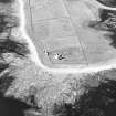
Drystone rectangular enclosure, one side of which is formed
by field dyke. Were it not for reported tradition would probably
be taken for a planticru although rather large for one. Lack of
an entrance gap suggests it is not a kro or fold.
Information from Orkney SMR (RGL) Aug 70.
Note (1980)
Start Island, Sanday HY 7831 4353 HY74SE(M)
A dry-stone walled rectangular enclosure is said to be a burial-ground of shipwrecked mariners, it is too large for a planticru, and lack of an entrance suggests that it is not a fold.
RCAHMS 1980
(OR 302)
Field Visit (1999)
A small drystone walled enclosure, built against a larger field wall, is alleged to mark the location of the burial place of a group of mariners, shipwrecked in the 19th century. Previous surveyors have noted that it appears too large for a planticrue but as it does not have an entrance gap it is unlikely to be a fold.
Coastal Zone Assessment Survey, 1999

