
Pricing Change
New pricing for orders of material from this site will come into place shortly. Charges for supply of digital images, digitisation on demand, prints and licensing will be altered.
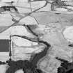
Arrat's Mill


Four Poster Stone Circle (Bronze Age)(Possible), Souterrain(S) (Iron Age), Unenclosed Settlement (Prehistoric)
Site Name Arrat's Mill
Classification Four Poster Stone Circle (Bronze Age)(Possible), Souterrain(S) (Iron Age), Unenclosed Settlement (Prehistoric)
Canmore ID 35752
Site Number NO65NW 39
NGR NO 6463 5857
Datum OSGB36 - NGR
Permalink http://canmore.org.uk/site/35752


- Council Angus
- Parish Brechin
- Former Region Tayside
- Former District Angus
- Former County Angus
NO65NW 39 6463 5857.
Tolan notes two pit-circles, one of them obscured by the cropmark of a souterrain.
M Tolan 1988.
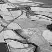
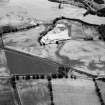
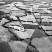
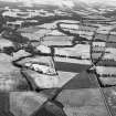
Aerial reconnaissance has recorded a number of cropmarks in a field some 250m ENE of Arrat's Mill. There is an interrupted ring-ditch at NO6463 5857 measuring about 20m across with three gaps in it's perimeter and a curved souterrain-like cropmark extending through the gap to the E. What appears to be a four-poster setting lies by the gap on the W side (at NO 6462 5857) and is approximately 4m square. There are also two pit-circles within ring-ditches nearby. The first, at NO 6460 5854, lying to the SW of the interrupted ring-ditch, is about 12m in diameter within two arcs of ditch on the N and S sides some 16m apart. Any possible continuation of the ditch to the E is obscured by other cropmarkings, but there appears to be a break in the W side for a souterrain which also has two smaller passages leading off to the W and hooks around within the pit-circle to the E. The second pit-circle, at NO 6460 5861, is smaller, about 10m in diameter surrounded by a broad arc of ditch curving around the S side which obscures the probable pits on that side. Pits are clearly visible on the N side as well as a narrow outer ditch to the E about 4m from the inner broad ditch. There are other maculae and cultivation remains in the field.
Transcription prepared by RCAHMS (MMB) 23 January 1996.
Information from RCAHMS (RHM) 23 August 1996.
Note (1983)
Arrat’s Mill NO 646 585 NO65NW 39
An arc of ditch, possibly the SE side of an enclosure, is revealed by cropmarks 280m ENE of Arrat's Mill.
RCAHMS 1983.
Aerial Photographic Transcription (23 January 1996 - 13 February 1996)
An aerial transcription was produced from oblique aerial photographs. Information from Historic Environment Scotland (BM) 31 March 2017.

