
Pricing Change
New pricing for orders of material from this site will come into place shortly. Charges for supply of digital images, digitisation on demand, prints and licensing will be altered.
Arrat's Mill


Rig And Furrow (Medieval) - (Post Medieval), Ring Ditch(S) (Prehistoric)(Possible)
Site Name Arrat's Mill
Classification Rig And Furrow (Medieval) - (Post Medieval), Ring Ditch(S) (Prehistoric)(Possible)
Canmore ID 35751
Site Number NO65NW 38
NGR NO 6473 5885
NGR Description NO 6473 5885 and NO 6474 5886
Datum OSGB36 - NGR
Permalink http://canmore.org.uk/site/35751


- Council Angus
- Parish Brechin
- Former Region Tayside
- Former District Angus
- Former County Angus
NO65NW 38 6473 5885 and 6474 5886.
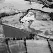
The ring-ditches, recorded through aerial reconnaissance, are situated to the N of the track leading to the sand and gravel pits, about 500m NE of Arrat's Mill. They both have a rectilinear appearance although the N one of the two (at NO 6474 5886) is more rounded and slightly smaller than the one to the S (at NO 6483 5885) which may have a slight gap to the NE. Both are less than 3m across and there are a few other small maculae in the field as well as an area of broad rig-and-furrow cultivation, aligned WSW-ENE.
Transcription prepared by RCAHMS (MMB) 23 January 1996.
Information from RCAHMS (RHM) 22 August 1996.
Note (1983)
Arrat's Mill NO 647 588 NO65NW 38
Two small ring-ditches, each with an internal diameter of about 1.5m are revealed by cropmarks 500m NE of Arrat's Mill.
RCAHMS 1983.
Aerial Photographic Transcription (23 January 1996 - 13 February 1996)
An aerial transcription was produced from oblique aerial photographs. Information from Historic Environment Scotland (BM) 31 March 2017.

