
Pricing Change
New pricing for orders of material from this site will come into place shortly. Charges for supply of digital images, digitisation on demand, prints and licensing will be altered.
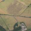
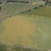
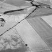
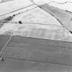
Powis


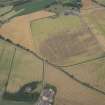
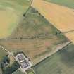
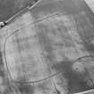
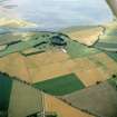
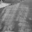
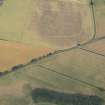
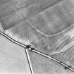
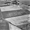
Cursus (Neolithic), Rig And Furrow (Medieval) - (Post Medieval), Ring Ditch(S) (Prehistoric)
Site Name Powis
Classification Cursus (Neolithic), Rig And Furrow (Medieval) - (Post Medieval), Ring Ditch(S) (Prehistoric)
Alternative Name(s) Old Montrose
Canmore ID 35706
Site Number NO65NE 51
NGR NO 6635 5692
Datum OSGB36 - NGR
Permalink http://canmore.org.uk/site/35706


- Council Angus
- Parish Maryton
- Former Region Tayside
- Former District Angus
- Former County Angus
NO65NE 51 6635 5692.
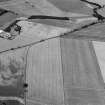
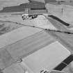
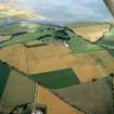
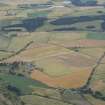
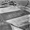
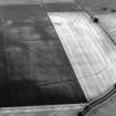
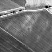
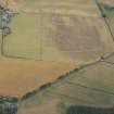
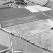
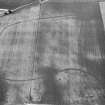
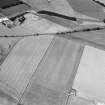
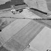
NO 669 566 A small amount of fieldwalking was undertaken in the vicinity of a series of cropmarks lying above the 15m contour on the valley floor. These include a large ditch-defined cursus, Old Montrose (NMRS NO65NE 36), several ring-ditches, round and square barrows, a souterrain, settlement (enclosed and unenclosed), and agricultural traces. They also include a large kidney-shaped enclosure and represent a complex and long-term sequence of human activity. A lithic scatter was previously known (Sherriff 1981). Rewalking produced waste flakes and chips of flint from NO 667 562: none has secondary working. In a field centred on NO 669 566 ? downslope of the cropmarks ? two chips and an awl or borer were found. All are of reddish flint. Other fields produced occasional flakes or pieces. More work will be done in this area.
Sponsor: Historic Scotland
K Brophy and E Stuart 1997.
Aerial Photographic Transcription (3 December 1993 - 17 January 1994)
An aerial transcription was produced from oblique aerial photographs. Information from Historic Environment Scotland (BM) 31 March 2017.

