
Pricing Change
New pricing for orders of material from this site will come into place shortly. Charges for supply of digital images, digitisation on demand, prints and licensing will be altered.
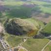
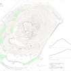
North Berwick Law


Quarry (Period Unknown)
Site Name North Berwick Law
Classification Quarry (Period Unknown)
Canmore ID 356986
Site Number NT58SE 141
NGR NT 5543 8434
Datum OSGB36 - NGR
Permalink http://canmore.org.uk/site/356986


- Council East Lothian
- Parish North Berwick
- Former Region Lothian
- Former District East Lothian
- Former County East Lothian
Field Visit (13 September 2018)
At the foot of the NW flank of North Berwick Law there is a disused and now heavily overgrown quarry that has been dug into the slope to a depth of more than 4m on the uphill side and 1m on the downhill. It measures about 140m from NE to SW by at least 16m transversely and there is a low mound of upcast along its lower edge and NE end. The quarry is accessed from the SW by a metalled trackway that is depicted on the 1st edition of the OS 6-inch map (Haddingtonshire Sheet 2, 1853) but not on later editions.
Visited by HES Survey and Recording (JRS, GFG, AM) 13 September 2018.
(NBL18)

