
Following the launch of trove.scot in February 2025 we are now planning the retiral of some of our webservices. Canmore will be switched off on 24th June 2025. Information about the closure can be found on the HES website: Retiral of HES web services | Historic Environment Scotland
Balwyllo


Palisaded Settlement (Prehistoric)(Possible)
Site Name Balwyllo
Classification Palisaded Settlement (Prehistoric)(Possible)
Alternative Name(s) House Of Dun Policies
Canmore ID 35685
Site Number NO65NE 32
NGR NO 66246 59487
Datum OSGB36 - NGR
Permalink http://canmore.org.uk/site/35685


- Council Angus
- Parish Dun
- Former Region Tayside
- Former District Angus
- Former County Angus
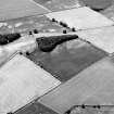
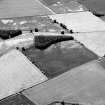
Note (1978)
Dun NO 662 594 NO65NE
The crop-mark of what may be an oval palisaded enclosure has been recorded on a gentle slope NE of Balwyllo. The enclosure measures a maximum of about 35m in diameter and there are traces of at least one internal structure.
RCAHMS 1978

