
Bush


Farmstead (19th Century) - (20th Century)
Site Name Bush
Classification Farmstead (19th Century) - (20th Century)
Canmore ID 356845
Site Number NX18NW 103
NGR NX 1425 8599
Datum OSGB36 - NGR
Permalink http://canmore.org.uk/site/356845

- Council South Ayrshire
- Parish Colmonell
- Former Region Strathclyde
- Former District Kyle And Carrick
- Former County Ayrshire
Field Visit (8 February 2018)
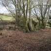
This farmstead, which appears to have been little more than a house with outshots, is depicted roofed on the 1st edition of the OS 6-inch map (Ayrshire 1858, Sheet LXVI), and is described in the contemporary OS Name Book as ‘a small farm steading consisting of a dwelling house, stable etc. to which is attached a small arable farm. The house is built of lime and stone, thatched roof, one storey high and in good repair. The property of Alexander Cathcart Esq. of Knockdolian.’ (No. 13, p.42). The house seems to have fallen out of house before 1953, when it is not depicted on a provisional edition of the OS 1:25,000 map (Sheet NX18). It is now roofless and ruined.
A second building, which stood on the NW bank of the Bush Burn some 20m SSE of the house, was not seen in dense undergrowth on the date of visit. It was built before the revised 2nd edition of the map was published in 1909 and it was depicted still roofed on the 1953 1:25,000 map.
Visited by HES Survey and Recording (GFG) 8 February 2018.

