
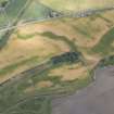
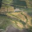
Dun


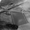
Rig And Furrow (Medieval) - (Post Medieval)
Site Name Dun
Classification Rig And Furrow (Medieval) - (Post Medieval)
Canmore ID 35683
Site Number NO65NE 30
NGR NO 6900 5930
NGR Description Centred on NO 6900 5930
Datum OSGB36 - NGR
Permalink http://canmore.org.uk/site/35683


- Council Angus
- Parish Dun
- Former Region Tayside
- Former District Angus
- Former County Angus
Note (1978)
Dun NO 690 593 NO65NE
Some indeterminate crop-marks have been recorded SE of the Roman temporary camp NO65NE 21.
RCAHMS 1978

