
Newbigging


Enclosure (Medieval) - (Post Medieval)
Site Name Newbigging
Classification Enclosure (Medieval) - (Post Medieval)
Alternative Name(s) Pugeston
Canmore ID 35678
Site Number NO65NE 26
NGR NO 6934 5959
NGR Description NO 6934 5959
Datum OSGB36 - NGR
Permalink http://canmore.org.uk/site/35678


- Council Angus
- Parish Montrose
- Former Region Tayside
- Former District Angus
- Former County Angus
Field Visit (April 1978)
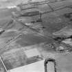
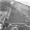
Newbigging NO 693 595 NO65NE
The crop-mark of a rectilinear enclosure has been recorded in a level field SW of Newbigging. The enclosure measures about 50m from E to W by 40m transversely, but no internal features can be identified with certainty.
RCAHMS 1978, visited April 1978

