 |
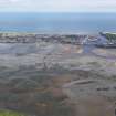
On-line Digital Images |
DP 091462 |
RCAHMS Aerial Photography Digital |
Oblique aerial view of the Montrose Basin at low tide centred on Dronner's Dyke, looking to the E. |
18/7/2010 |
Item Level |
|
 |
On-line Digital Images |
SC 2410495 |
Records of the Ordnance Survey, Southampton, Hampshire, England |
Dronner's Dyke, NO65NE 15, Ordnance Survey index card, Recto |
c. 1958 |
Item Level |
|
 |
On-line Digital Images |
SC 2410496 |
Records of the Ordnance Survey, Southampton, Hampshire, England |
Dronner's Dyke, NO65NE 15, Ordnance Survey index card, Recto |
c. 1958 |
Item Level |
|


