
Dronner's Dyke


Dyke (17th Century)
Site Name Dronner's Dyke
Classification Dyke (17th Century)
Canmore ID 35666
Site Number NO65NE 15
NGR NO 6870 5771
NGR Description From NO 6870 5771 to NO 6999 5780
Datum OSGB36 - NGR
Permalink http://canmore.org.uk/site/35666


- Council Angus
- Parish Dun
- Former Region Tayside
- Former District Angus
- Former County Angus
NO65NE 15 6870 5771 to 6999 5780.
(NO 6870 5771 - NO 6999 5780) Dronner's Dyke (NR) (remains of)
OS 1:10,000 map, (1972)
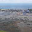
Dronner's Dyke was a long, piled construction built in 1677 by Dronner, a Dutch engineer, but shortly afterwards destroyed in a storm. Its purpose was to facilitate the draining of the Basin and the reclaiming of c. 2,000 acres of land. At low tides the remains are partly visible. The name is sometimes corrupted to Drainer's or Drainner's Dyke.
A Jervise 1861; G Cumming 1843; Statistical Account (OSA) 1793.
At low tide a slight scatter of stones can be seen on the line of Dronner's Dyke.
Visited by OS (J L D) 26 June 1958.
Note (1978)
Dronner's Dyke NO 687 577 to 699 578 NO65NE 15
This dyke was constructed in the late-17th century with the intention of reclaiming about 2000 acres of the Montrose Basin from the sea. However, it was destroyed shortly after its completion, and little now survives.
RCAHMS 1978
(Stat Acct, v, 1793, 26)

